


The national harvest of cereals, legumes, and oilseeds in 2025 was 18% higher than in 2024, setting a record in the historical series. Rice, corn, and soybeans are the three main products, accounting for 93% of the estimated production and 88% of the harvested area (photo: CONAB)
Tool uses remote sensing to reduce uncertainties regarding agricultural losses, contributing to public policy.
Tool uses remote sensing to reduce uncertainties regarding agricultural losses, contributing to public policy.
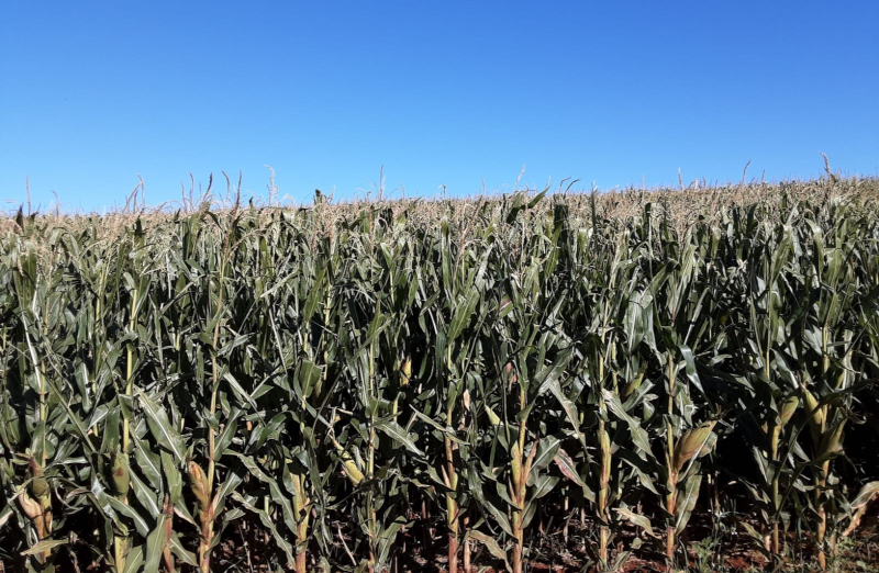
The national harvest of cereals, legumes, and oilseeds in 2025 was 18% higher than in 2024, setting a record in the historical series. Rice, corn, and soybeans are the three main products, accounting for 93% of the estimated production and 88% of the harvested area (photo: CONAB)
By Luciana Constantino | Agência FAPESP – Brazilian researchers have developed a methodology that uses remote sensing to map the impact of frost on corn crops. This reduces exposure to climate risks and uncertainty regarding agricultural losses.
The model allows users to customize a set of variables, making it useful for other crops in different agricultural contexts. Thus, it has the potential to provide more accurate estimates during harvests and contribute to the development of public policies that support production chains and insurance systems.
Global grain production, particularly of rice, corn, wheat, and soybeans, is concentrated in just five countries: China, the United States, India, Brazil, and Argentina. Fluctuations in harvests in these countries can affect both prices and the global supply. These crops have also been affected by climate change, experiencing severe droughts, extreme rainfall, and more frequent frosts. This issue has been brought to negotiation rounds such as COP30, held in Belém.
In the study, the scientists mapped over 700,000 hectares of corn planted for the second harvest in the western mesoregion of Paraná state (in the areas around Toledo and Cascavel) to identify damage caused by severe frosts recorded between May and June of 2021.
The scientists integrated optical remote sensing data (MultiSpectral Instrument sensor with medium spatial resolution aboard the Sentinel-2 mission satellites) with machine learning techniques (Random Forest algorithm). They achieved 96% accuracy in mapping corn crops and revealed that 70% were damaged by frost during that time. They were able to map the affected areas using the method they called GEEadas.
The results were published in the December issue of the journal Remote Sensing Applications: Society and Environment.
“In 2021, we had a drought that disrupted soybean planting in Paraná and, as a result, delayed corn planting. Then, in June, came the news of the frost. That region normally has high rainfall, which benefits crops. But we see that the climate in recent years hasn’t been normal,” says Marcos Adami, a researcher from the Earth Observation and Geoinformatics Division (DIOTG) of the National Institute for Space Research (INPE) and one of the authors of the article. “A crop failure there greatly affects the lives of the people, most of whom depend on agribusiness. Developing this study is a way to provide tools that give answers and contribute to the planning of measures that help maintain this important activity.”
Adami has been working with Professor Michel Eustáquio Dantas Chaves, from the Faculty of Sciences and Engineering at São Paulo State University (UNESP) in Tupã, for several years on remote sensing research focused on practical applications in agriculture.
“Producers still face a number of climatic uncertainties during the harvest, especially when there are extreme events, such as frost, which have social, economic, and environmental impacts. In such cases, it’s necessary to identify how much of the crop has been affected in order to inform the farmer, the banks that grant credit, or institutional bodies. This method provides accuracy, indicating the affected area and reducing uncertainties,” says Chaves, first author of the article, which received support from FAPESP.
Importance of the sector
In its October 2025 estimate, the Brazilian Institute of Geography and Statistics (IBGE) reported that the national harvest of cereals, legumes, and oilseeds reached 345.6 million tons, which is 18% higher than in 2024 and a record high in the historical series. The three main products are rice, corn, and soybeans, which together account for 93% of the estimated production and 88% of the harvested area.
Paraná is the second-largest grain producer in Brazil, behind only Mato Grosso. The production estimate for corn in 2025 was 141.6 million tons, which is also a record.
The 2019/2020 harvest produced around 103 million tons, according to the study. This was double the amount produced in the previous decade, with three-quarters of the supply coming from the second harvest. In that harvest, corn is grown after soybeans and is harvested between June and July. This increase was made possible by changes in management practices, such as adopting new fertilizers and cultivating short-cycle corn.
Generally, the second corn crop is riskier than the first due to lower water availability and exposure to climatic events, including frost. Despite having frost risk warning systems, Brazil lacks accurate methodologies to assess damage.
To validate the method, the researchers compared corn mapping areas and frost damage estimates with official data provided by the State Department of Agriculture and Supply. They also used information from insurance companies. Farmers typically file insurance claims to recover losses caused by adverse events. For each claim, an agricultural specialist visits the farm and analyzes the damage.
“In the field, agricultural technicians have spatial limitations, which are natural to the activity. Seeing from above with remote sensing images allows us to complement the technicians’ work,” Chaves explained to Agência FAPESP.
Adami says he is working with the National Supply Company (CONAB) in the states of Rio Grande do Sul, Paraná, and São Paulo to develop methodologies and collect data to obtain more accurate crop yield figures.
The article “GEEadas: GEE-based automatic detection of adverse-frost stress” can be read at sciencedirect.com/science/article/pii/S2352938525003520.
The Agency FAPESP licenses news via Creative Commons (CC-BY-NC-ND) so that they can be republished free of charge and in a simple way by other digital or printed vehicles. Agência FAPESP must be credited as the source of the content being republished and the name of the reporter (if any) must be attributed. Using the HMTL button below allows compliance with these rules, detailed in Digital Republishing Policy FAPESP.
