

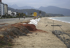
Barrier to protect the beach from the force of the waves. A study conducted by researchers from São Paulo and Pernambuco details coastal vulnerability in these states (photo: Eduardo Siegle)
A study conducted by researchers from São Paulo and Pernambuco details coastal vulnerability in the two states.
A study conducted by researchers from São Paulo and Pernambuco details coastal vulnerability in the two states.
Barrier to protect the beach from the force of the waves. A study conducted by researchers from São Paulo and Pernambuco details coastal vulnerability in these states (photo: Eduardo Siegle)
By Fabio Reynol
Agência FAPESP – Coastal areas often suffer from changes caused by nature, such as increasing sea levels and wave systems. With climate change, the natural elements that influence beach alterations, called forcing conditions, are expected to gain strength and modify the structure of the coastline.
Research on the damage sustained by four beaches in São Paulo and Pernambuco concluded, however, that the destructive effects of humans could be even stronger than those of nature.
Conducted with support from FAPESP and the Pernambuco Research Foundation (FACEPE), the study is the result of a call for proposals launched under the cooperative agreement between the two institutions.
The study, “Vulnerability of the coastal area of the states of São Paulo and Pernambuco: current status and projections for climate change scenarios,” lasted three years, a period that included the study of the São Paulo beaches of Ilha Comprida, in the municipality of Ilha Comprida, as well as Massaguaçu, in Caraguatatuba, and the Pernambucan beaches of Piedade, in Jaboatão dos Guararapes, and Paiva, in Cabo de Santo Agostinho.
“We selected beaches with different characteristics in order to make our comparisons. Massaguaçu, on the northern coast of the state of São Paulo, and Jaboatão, in the metropolitan Recife area, are urban beaches, while Ilha Comprida and Paiva are situated in less populated areas,” said the project coordinator, Eduardo Siegle, professor at the Oceanographic Institute of the University of São Paulo (IO/USP), who is co-leader of the study with Professor Tereza Araújo of the Federal University of Pernambuco (UFPE).
The study analyzed how global climate change is causing alterations to the coast. One of the forcing conditions examined was wave climate. According to Siegle, climate change causes alterations in wind systems, which are the main influence on the formation of waves. With altered direction and strength, the waves could redesign the outline of the beaches, ultimately changing their morphology.
“The waves redefine the deposit of sediments and the beaches reach a dynamic equilibrium through the conditions they are subjected to; some points may be eroded while other points see the deposit of additional material,” Siegle said, adding that a beach can shrink, change shape and even increase in size.
Another factor arising from climate change is sea-level rise, which causes an increase in wave height and allows water levels to reach new points along the coastline. The condition generally exacerbates beach erosion and causes flooding in coastal areas.
One point confirmed by the results was that, in some regions, anthropic activities along the coastline have more influence on these alterations than the forces of nature itself. “We’ve been monitoring images for decades. During this period, the impacts of poorly executed occupation along the coastline can be worse than those caused by climate change,” Siegle said.
Urbanization processes that isolate beach areas needed for the movement of sediments often cause even more severe erosion. In the study, human activity was found to be one of the main factors in coastal variability.
Observations of coastal processes
The investigators also examined historical changes in the forcing conditions. To do this, the team used computer models that simulated these forces and their effects over recent decades. Another method involved the collection of field data. The researchers conducted morphological surveys that analyzed the shape of the beaches and measured the parameters of the waves.
Measurement of physical variations in the coastal region required the use of innovative measures to place instruments in areas where waves break, Siegle noted. The team used a jet ski to tow an acoustic Doppler current profiler.
The equipment provides data for wave parameters such as water column, current speed, height, direction and period. The jet ski was used for nearshore bathymetric and hydrodynamic surveys in shallow areas of breaking waves where conventional watercraft cannot navigate.
A series of aerial images recorded over approximately 40 years served as another important source of data for the study. The group accessed archives from the National Institute for Space Research and the Oceanographic Institute of USP. By using georeferenced points marked on the images, it was possible to analyze the changes of the coastline over time.
On the basis of the data collected through the various methods, the group established nine indicators of vulnerability: position of the coastline, beach width, terrain elevation, coastal engineering works, soil permeability, vegetation, presence of rivers or estuaries, rate of occupation and general configuration. The last indicator refers to the area of open sea adjacent to the coastal region under study.
Wider beach systems tend to be more stable than narrow bands and thus less vulnerable. The presence of well-developed vegetation in the backshore suggests a scenario of low erosion and rare intrusion of salt water.
Vulnerability to flooding can be estimated using factors such as soil permeability. The less permeable the soil, the more the area is subject to flooding. Because it simultaneously alters several of these factors, a rising rate of coastal occupancy is one of the most reliable indicators of coastal area vulnerability.
The indicators were then tabulated and classified according to three degrees of vulnerability— high, average or low—for each year analyzed. The changing vulnerability of each beach was recorded, and the researchers arrived at several conclusions. “Among them, I would underscore the significance that human occupation along the coast has had in increasing beach vulnerability,” Siegle said. The urban beaches in the two states presented more vulnerability than the beaches with lower occupancy rates.
The use of this method was detailed in the dissertation by Paulo Henrique Gomes de Oliveira Sousa, entitled “Vulnerability of the São Paulo coast to erosion: interaction between coastal processes and anthropic activities,” which he defended in 2013 during his graduate program in oceanography at the IO/USP.
The research project resulted in five undergraduate papers, four master’s theses and two dissertations, one of which received a FAPESP scholarship – Cássia Pianca Barroso wrote the paper “Extracting coastal variables from video images: short to medium-term coastal processes.”
According to Siegle, several articles are being written and four have already been published, including “Evolution of vulnerability to coastal erosion at Massaguaçú Beach (SP) Brazil,” in the Journal of Integrated Coastal Management, and “Vulnerability assessment of Massaguaçú Beach (SE Brazil),” in the journal Ocean & Coastal Management.
São Paulo-Pernambuco partnership
In addition to the scientific findings, the project presented the opportunity for collaboration between the São Paulo and Pernambucan research institutions. “There was extensive interaction, and Pernambucan researchers took part in field studies in São Paulo and vice-versa,” Siegle said.
The partnership between the groups led to another joint FAPESP-FACEPE study, the project “Susceptibility and resilience of urban estuarine systems to global changes: hydro-sedimentologic budget; sea-level rise; response to extreme events,” coordinated by professors Carlos Schettini (UFPE) and Rubens Cesar Lopes Ferreira (IO/USP).
The project coordinated by Siegle and Tereza Araújo also led to the establishment of the “Coastline Responses” Working Group that is part of the National Institute of Science and Technology for Tropical Marine Environments (AmbTropic). The institute is housed at the Geosciences Institute of the Federal University of Bahia and supported by the National Council for Scientific and Technological Development (CNPq) and the Bahia Research Foundation (FAPESB).
The Agency FAPESP licenses news via Creative Commons (CC-BY-NC-ND) so that they can be republished free of charge and in a simple way by other digital or printed vehicles. Agência FAPESP must be credited as the source of the content being republished and the name of the reporter (if any) must be attributed. Using the HMTL button below allows compliance with these rules, detailed in Digital Republishing Policy FAPESP.
