


Paleoclimate research shows that a collapse of this process in the past caused long periods of torrential rain in northeastern Brazil and increased CO2 emissions in the vicinity of Antarctica, among other consequences (image: NASA/Goddard Space Flight Center Scientific Visualization Studio)
Paleoclimate research shows that a collapse of this process in the past caused long periods of torrential rain in northeastern Brazil and increased CO2 emissions in the vicinity of Antarctica, among other consequences.
Paleoclimate research shows that a collapse of this process in the past caused long periods of torrential rain in northeastern Brazil and increased CO2 emissions in the vicinity of Antarctica, among other consequences.
Paleoclimate research shows that a collapse of this process in the past caused long periods of torrential rain in northeastern Brazil and increased CO2 emissions in the vicinity of Antarctica, among other consequences (image: NASA/Goddard Space Flight Center Scientific Visualization Studio)
By José Tadeu Arantes | Agência FAPESP – By the end of the century, climate change may reduce the gigantic oceanic circulation that carries heat from the South Atlantic to the North Atlantic by almost half. If this happens, the consequences will be dramatic, both globally and above all for the coastal regions of the three continents bathed by the Atlantic – America, Europe and Africa.
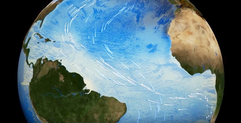
Scientists call this phenomenon the Atlantic meridional overturning circulation (AMOC). It is characterized by a northward flow of warm, salty water in the upper layers of the Atlantic and a southward flow of colder water in the deep Atlantic. Its importance as a component of the Earth’s climate system is evidenced by the fact that the amount of heat energy transported per second is 1.3 petawatts (1.3 x 10¹⁵ W), almost 100,000 times greater than the power generated by the Itaipu hydroelectric dam on the Brazil-Paraguay border with all turbines operating. According to the Intergovernmental Panel on Climate Change (IPCC), under a worst-case scenario, the power of this conveyor belt will fall by 44% by 2100.
If this happens, 44% of the thermal energy now transported to the cold waters of the North Atlantic at high latitudes will instead stay in the southern hemisphere, circulating in the South Atlantic and Southern Ocean and affecting high and low pressure systems, wind regimes, rain intensity and rain duration, among other factors.
One way to validate the accuracy of these projections and design future scenarios more precisely is by looking at the past, i.e., “running the model backwards”, and comparing the results obtained by simulation with concrete data collected by field surveys.
This is the purpose of the project “Response of the Western Atlantic Ocean to changes in the Atlantic meridional overturning circulation: from millennial to seasonal variability” conducted by Cristiano Mazur Chiessi, a paleoclimatologist and professor at the University of São Paulo’s School of Arts, Sciences & Humanities (EACH-USP) in Brazil. The project is supported by FAPESP under the aegis of its Young Investigator Program.
“Our project seeks to investigate how changes that occurred thousands of years ago in the Atlantic oceanic circulation affected the climate of South America and the western portion of the South Atlantic at that time. One of these effects, which occurred when the cell’s intensity diminished drastically or the cell itself collapsed, was a long period of torrential rain over the northeastern region of what is now Brazil,” Chiessi told Agência FAPESP.
Under present conditions, the AMOC is a large-scale cell that picks up warm salty water at the top of the water column in the South Atlantic and conveys it to high latitudes in the North Atlantic.
“On the way, the intense evaporation that occurs at low latitudes causes an increase in the water’s already substantial salinity. The cooling that occurs later on, at high latitudes, causes a contraction in volume. The combination of higher salinity and lower volume make the water denser, and because of its greater density it sinks down the water column to return to the South Atlantic as a deep, cold layer until it reaches the vicinity of Antarctica,” Chiessi explained (see animation at www.youtube.com/watch?v=LkRQjTdTvFE).
More specifically, the warm current moves northward along the east coast of South America, from an area roughly level with Salvador in Brazil to an area roughly level with New York in the US. It then turns east toward Iceland and Norway, and after reaching northern Europe it plunges down to turn south again as a cold deep current that flows parallel to the east coast of the Americas almost all the way to Antarctica.
The current plunges because of heat loss at two specific sites: the Labrador Sea between Canada and Greenland, and the Norwegian Sea between Greenland, Iceland and Norway. “Owing to this release of heat, the average temperature at the ocean surface near southern Norway or northern Britain is much higher than on the Canadian coast at the same latitude,” Chiessi said.
The cell exerts a very strong influence on the climate, not just over the ocean but also over all the adjacent continents. “This is especially true for the portions of these continents that are bathed by the Atlantic,” he added. “In South America, everything east of the Andes is highly influenced by the phenomenon.”
The intensity of this oceanic process is already declining because of climate change, according to Chiessi.
“Global warming cools the circulation in two ways,” he said. “First, rainfall increases at high latitudes of the North Atlantic, precisely where the water needs more density to plunge down to the bottom and turn back southward. If it rains a lot in these regions, the surface water becomes less salty and therefore less dense, hindering the downward plunge. Second, the melting of the ice cap over Greenland releases fresh water, which is much less salty, precisely at the sites of deep water formation.”
Torrential rain for long periods in northeastern Brazil
According to Chiessi, uncertainty about the projections is still significant. Current models work well for some variables, less well for others. This is the main motivation for investigating periods in the past when the AMOC weakened or even collapsed, which is so that consequences can be identified, especially on the western side of the South Atlantic.
“The most recent iconic period of reduction in oceanic circulation was 18,000-15,000 years ago during the last great deglaciation,” he said. “As the planet heated up, glaciers at high latitudes of the northern hemisphere, especially over Canada, melted and poured an enormous amount of fresh water into the Sea of Labrador, cooling or even paralyzing the AMOC.”
To estimate the magnitude of the thaw, it is necessary to go back another millennium to 19,000 years ago, when glaciation peaked. Levels of carbon dioxide in the atmosphere were then approximately 175 parts per million (ppm), compared with over 400 ppm now, and sea levels were 130 m lower than today. All the water corresponding to this massive difference was imprisoned in the continent’s glaciers, especially over Canada and the northern US.
In several parts of the planet, the coastline had advanced hundreds of kilometers over the area now occupied by the oceans. It would have been possible to travel on foot from the Malvinas (Falklands) to Argentina, from southern England to France, and from northeast Asia to the northwest of North America. The English Channel did not exist, nor did the Bering Strait. These regions were above the water line.
“Between 18,000 and 15,000 years ago, the glaciers began to send astounding quantities of icebergs into the Sea of Labrador as the climate warmed up,” Chiessi said. “Surface water salinity, and hence the intensity of the AMOC, decreased as a result. Some people believe the circulation may have even collapsed completely. All that heat energy, corresponding to 1.3 petawatts, had to be redistributed elsewhere in the South Atlantic and Southern Ocean. Antarctica warmed up considerably as a result.”
The intertropical convergence zone (ITCZ) therefore shifted south. The ocean surface is warmer in the ITCZ, so there is more convection, cloudiness and rainfall. Today, the ITCZ is located 5-10 degrees north of the equator on average. In the era just mentioned, it migrated south of the equator, causing torrential rain for long periods in northeastern Brazil.
“One of our papers, published in Earth and Planetary Science Letters last year, brought this phenomenon to light,” Chiessi said, referring to the article “Origin of increased terrigenous supply to the NE South American continental margin during Heinrich Stadial 1 and the Younger Dryas”.
This study found a colossal increase in the rate at which sediment was deposited on the ocean floor, owing to erosion by rain and intensifying river sediment discharge into the sea. The sedimentation rate at a depth of 1 km offshore of the mouth of the Parnaíba (present-day Piauí State) reached 100 cm in 1,000 years. This is equivalent to the sedimentation rate for a gigantic river like the Amazon. The Parnaíba is much smaller.
“Because of the torrential rainfall over northeastern Brazil, in some places the Parnaíba deposited an amount of sediment equivalent to the volume deposited by the Amazon. There is evidence of a dramatic decrease in rainfall in the same period to the north, in Venezuela and Central America,” Chiessi said.
“We collected and analyzed sediment cores of between 8 m and 9 m at two marine sites, one offshore of the mouth of the Parnaíba at a depth of 1,367 m and the other offshore of French Guiana at 2,510 m.”
According to Chiessi, sediment cores are collected as follows. The first step is an echo-sounding survey of the ocean bed to observe whether the layers of sediment have been disturbed. If not, a gravity coring rig weighing more than 5 metric tons is lowered to the ocean bed, where it collects an 8 m to 10 m sediment column by gently penetrating the seafloor to avoid disturbing the sediment. Laboratory analysis of each fraction of the column produces a wealth of information.
Lag between warming of ocean and continent
“Another study of ours using basically the same methodology showed that the warming of the South Atlantic didn’t lead to an immediate rise in temperatures on the continent,” Chiessi said. “The ocean became warmer some 18,000 years ago, but this was reflected on dry land only about 16,500 years ago. There was a lag of a millennium and a half.”
According to Chiessi, it was only when deglaciation triggered a rise in atmospheric carbon dioxide levels that higher temperatures at last began to emerge on land. This conclusion was reported by Chiessi and collaborators in an article published in Climate of the Past, a journal of the European Geosciences Union, entitled “Thermal evolution of the western South Atlantic and the adjacent continent during Termination 1”.
Here, it is important to be precise about the causal sequence. First, the onset of the deglaciation process poured fresh water into the Labrador Sea, cooling the oceanic circulation cell or triggering its collapse. Next, the heat trapped in the South Atlantic raised the temperature of the water not only off the east coast of South America but also around Antarctica. As a result, the westerly winds that blow intensely over Patagonia migrated southward, bolstering the upwelling in the vicinity of Antarctica.
Upwelling is a process in which warm surface water is replaced by cold water from below. Winds blowing across the ocean push the surface water away, and nutrient-rich water wells up from deeper regions to replace it.
On the one hand, the intensification of the upwelling fueled an explosion of marine life in the region, as the many nutrients on the ocean floor became available nearer the surface. On the other hand, it released into the atmosphere a large amount of carbon dioxide that had been trapped in the depths, and this greenhouse gas produced the additional warming that brought the last ice age to an end.
“The link between the last deglaciation and rising CO2 levels in the atmosphere was discovered by Jeremy Shakun, who reported his finding in a famous article published by Nature in 2012. It made a strong impression on the scientific community and has been cited many times,” Chiessi said, referring to “Global warming preceded by increasing carbon dioxide concentrations during the last deglaciation”.
“So, we aren’t claiming to be first in suggesting this mechanism. What is original in our paper is our confirmation of Shakun’s assertion by analyzing an ocean temperature curve and a continental temperature curve in one and the same sediment core.”
He estimated ocean temperatures on the basis of chemical analysis of planktonic foraminifera, tiny fossils of marine organisms preserved in the various layers of the sediment column. To estimate continental temperatures, he analyzed lipids produced by bacteria in soil microbiota swept into the ocean by surface runoff. In this way, he was able to derive ocean and land temperatures from the same sediment core.
“That was highly productive because it eliminated the problem of having to synchronize records,” Chiessi said. “They were already synchronized because they were in the same sediment column. We constructed the curves and found that continental temperatures didn’t reflect the rise in ocean temperatures in the short term. In fact, they only rose when CO2 levels increased, not before.”
In Chiessi’s view, this lag between ocean warming and land warming is additional evidence that the Earth only really emerged from the last glaciation when atmospheric CO2 levels rose, as Shakun had argued. The special significance of the discovery of the role of CO2 resides in the fact that, until quite recently, the beginnings and ends of glaciations were attributed solely to variations in the Earth’s orbit.
“The correlation between glaciations and orbital variations, established by Serbian geophysicist Milutin Milankovitch (1879-1958), predominated between the 1950s and the 1980s,” he said. “In the 1990s, however, researchers began to feel that this model made sense but was incomplete. Something was missing. And that something is precisely the role of CO2, which Shakun proved to be fundamental to the consummation of deglaciation.”
Approximately 15,000 years ago, the oceanic circulation cell was “switched on” again, abruptly changing the situation. In a few decades the temperature in Europe rose 6-7 degrees Celsius, a regional warming phenomenon due to redistribution of the thermal energy that had been trapped in the South.
There were lesser fluctuations later on, however, and these were the focus of a third paper by Chiessi and collaborators published in Paleoceanography: “Holocene shifts of the southern westerlies across the South Atlantic”.
Studying the past to fine-tune scenarios for the future
“In this third study, we changed the timeframe to focus on the changes that have taken place in the past 10,000 years,” Chiessi said. “They were not as significant as the changes involved in deglaciation, but they’re relevant to the construction of scenarios today, not least because the prediction for the end of this century is that the ocean circulation won’t collapse but will diminish by about 44%. It’s important to note that the projections don’t point to a collapse. This is why we decided to investigate what happened to the westerly winds during the Holocene, when there was also a partial reduction in the AMOC.”
Three sediment cores were selected for this purpose: one from offshore Rio Grande do Sul in Brazil, a second from offshore Buenos Aires, and a third from a little farther south along the coast of Argentina. Analysis of these cores enabled the researchers to reconstruct the characteristics of the southern westerlies over the last 10,000 years. They concluded that these winds shifted southward from the early to mid-Holocene.
“We investigated this not-so-distant past using the same model as the IPCC’s model for future climate projections, so the study also served to validate the model,” Chiessi said. “The model clearly reproduced the pattern we detected empirically. However, it underestimated the southward migration of the southern westerlies by an order of magnitude. In other words, it estimated as 10 something that was actually closer to 100. Now, the model also projects southward wind migration in the future. If we detected underestimation by an order of magnitude in comparison with data on the past, it’s possible that the projection may be an underestimation on the same scale.”
According to Chiessi, “the model got wind direction right as well as the duration of the variation, but it didn’t accurately measure the amplitude of the change. This is alarming. It could mean that southward wind migration between now and the end of the century will actually be much greater.”
This could entail, among other things, a reduction in the area of carbon sequestration located to the south of the westerlies on the coast of Argentina and an increase in the area of carbon emission located to the north of the westerlies on the coast of Uruguay and Brazil. Thus, the amount of carbon emission risk may be even greater than currently projected.
All three studies provide evidence of the importance of the interrelationships between paleoclimatology, current climatology and climate modeling for future climate forecasting, in terms of detecting past events that offer an analogy with future events and testing the accuracy of projections by means of a comparison between simulations and empirical data.
“In addition, paleoclimatology opens up the horizons of climate models by highlighting reactions that aren’t necessarily linear,” Chiessi said. “It’s difficult for the models to handle non-linear variables. Information on the past can help improve the projections.”
Between March 21 and April 15, the German research vessel Meteor conducted an oceanographic survey known as SAMBA, short for South American Hydrological Balance and Paleoceanography during the Late Pleistocene and Holocene. The expedition sailed from Rio de Janeiro and docked at Fortaleza in Brazil, collecting data and sampling the water column and ocean floor sediments on the way. The team included researchers from Heidelberg University in Germany (André Bahr) and from the Federal University of Rio de Janeiro State (Ana Luiza Albuquerque) and the University of São Paulo (Cristiano M. Chiessi) in Brazil, among others.
The Agency FAPESP licenses news via Creative Commons (CC-BY-NC-ND) so that they can be republished free of charge and in a simple way by other digital or printed vehicles. Agência FAPESP must be credited as the source of the content being republished and the name of the reporter (if any) must be attributed. Using the HMTL button below allows compliance with these rules, detailed in Digital Republishing Policy FAPESP.
