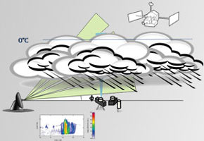

Research project studies the internal structure of storms in Brazil with the goal of collecting data to help predict extreme phenomena as far ahead as possible (Inpe)
Research project studies the internal structure of storms in Brazil with the goal of collecting data to help predict extreme phenomena as far ahead as possible
Research project studies the internal structure of storms in Brazil with the goal of collecting data to help predict extreme phenomena as far ahead as possible

Research project studies the internal structure of storms in Brazil with the goal of collecting data to help predict extreme phenomena as far ahead as possible (Inpe)
By Mônica Pileggi
Agência FAPESP – Predicting extreme phenomena in Brazil—such as the storms that frequently hit many regions during summer months—with as much notice as possible is still a challenge to meteorologists.
In an attempt to keep such events from becoming catastrophic, a group of researchers from the Center for Weather Forecasting and Climatic Studies at the National Institute for Space Research (CPTEC-Inpe) seeks to understand the internal structure of storms resulting from the country’s main precipitation regimes.
The group is part of the FAPESP Thematic Project Cloud processes of the main precipitation systems in Brazil: a contribution to cloud scale modeling and the GPM (Global Precipitation Measurement), coordinated by meteorologist and full time CPTEC researcher, Luiz Augusto Machado.
Christened “Projeto Chuva” [The Rain Project], the undertaking studies the microphysics of clouds (meaning the physical processes that go on inside them) to develop a numeric model to run on the Tupã supercomputer, operational since January at the Centro de Previsão do Tempo e Estudos Climáticos [Center for Weather Forecasting and Climate Studies] in Cachoeira Paulista (SP).
“Because of Tupã’s greater spacial resolution capacity, it’s necessary to create parameters and describe the elements in more detail. This means measuring the size of the hydrometeors (particles found inside clouds) such as drops of liquids, hail, graupel (soft hail) and snow in addition to their distribution in climatic systems,” said Machado to Agência FAPESP.
The data collection and analysis process will take place at seven locations across Brazil that comprise the main precipitation regimes in the country. “Our objective is to create a databank from these microphysics structures and verify whether or not they adjust themselves to this high special resolution of up to one kilometer,” he said.
The experiments started in March, 2010 at the Alcântara Launch Center in Maranhão State. Researchers then went to Fortaleza, Ceará State, where they built a tower to hold the double polarization mobile radar. The equipment, considered one of the most modern in the field, is now installed on the top of the building of the Meterology Department at the Universidade Federal do Pará in Belém.
Aside from providing data and measurements for cloud structures, the radar, together with a series of meteorology equipment, will allow scientists to understand the processes of precipitation related to the microphysics of clouds such as the formation of electrical discharge, radioactive effects and interaction with aerosols.
“The droplets’ influence on climate has many implications ranging from radioactive processes to climate change,” explained Machado.
In this process, defined as systems tomography, the focus of studies in Fortaleza was coastal precipitation--the so-called “hot clouds” responsible for most rainfall in the tropics. In Belém, researchers are studying rainfall in lines of instability formed by large cumulonimbus clouds that bring on intensive rainfall when they penetrate inland Amazônia.
New satellite
At the end of 2011, it will be the Vale do Paraíba’s turn, inland São Paulo state, where the South Atlantic convergence zone predominates and local storms are formed.
After that, the group will study the complex convective mesoscale weather in Foz do Iguaçu. This system is responsible for the formation of large agglomerates of clouds that represent 90% of the precipitation in Brazil’s South.
Afterward, the scientists will return to Manaus in the North to study the diverse weather regimes in Amazônia, including local intense convection and organized convection. From there, the group will head to Brasília to study rainfall relative to the penetration of organized cold fronts to Brazil’s central region.
Courses for meteorologists about the equipment used in the studies will be offered in each of these locations. “Remote sensing by satellite and radar, microphysics and computer modeling are new to the sector. Because of this, there are few specialists on the topic in Brazil,” said Machado.
Aside from knowledge about the microphysics of clouds, the data obtained in each system will be applied to the development of algorithms for a new Brazilian satellite.
With launch expected for 2015, the satellite will be part of the Global Precipitation Measurement Program, led by the NASA (United States) and JAXA (Japan) Space Agencies to monitor precipitation worldwide in 25 square kilometer areas every three hours.
Republish
The Agency FAPESP licenses news via Creative Commons (CC-BY-NC-ND) so that they can be republished free of charge and in a simple way by other digital or printed vehicles. Agência FAPESP must be credited as the source of the content being republished and the name of the reporter (if any) must be attributed. Using the HMTL button below allows compliance with these rules, detailed in Digital Republishing Policy FAPESP.


