


Sea and tide levels in São Paulo State's most important port city are expected to rise 18-30 cm by 2050, according to an international study (photo: Wikimedia Commons)
Sea and tide levels in São Paulo State's most important port city are expected to rise 18-30 cm by 2050, according to an international study.
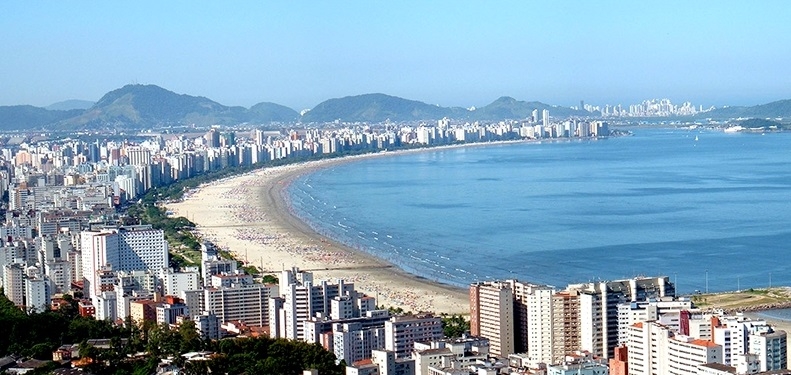
Sea and tide levels in São Paulo State's most important port city are expected to rise 18-30 cm by 2050, according to an international study.
Sea and tide levels in São Paulo State's most important port city are expected to rise 18-30 cm by 2050, according to an international study (photo: Wikimedia Commons)
By Elton Alisson
Agência FAPESP – Sea levels at the coastal city of Santos, in São Paulo State, Brazil, may rise between 18 and 30 centimeters by 2050.
Moreover, the area is expected to experience more frequent extreme storms as a result of climate change. These storms, combined with high sea levels, could mean extreme lunar tides, leading to severe flooding as the sea advances inland in the coastal parts of the city and causing economic damage.
The predictions are from an international study by Brazilian researchers at the Natural Disaster Surveillance & Early Warning Center (CEMADEN), the National Space Research Institute (INPE), the University of São Paulo (USP) and the University of Campinas (UNICAMP) in partnership with colleagues at the University of South Florida (USA) and King’s College London (UK), as well as technical staff employed by the City of Santos.
The results of the study, which is part of the project “An integrated framework to analyze local decision making and adaptive capacity to large-scale environmental change: community case studies in Brazil, UK and US” supported by FAPESP under a cooperation agreement with the Belmont Forum, were presented on September 30 to representatives of civil society in Santos.
During the meeting, the researchers showed city authorities and community leaders their projections for sea levels and the economic impact on the southeastern and northwestern areas of Santos, already affected by a rise in sea levels. The idea was for participants to discuss possible adaptive measures to minimize risks.
“The study is the first to estimate the dollar damage to the city while also showing how certain areas of Santos may be affected by flooding due to rising sea levels in the decades ahead,” said climatologist José Marengo, CEMADEN’s head researcher and coordinator of the project on the Brazilian side, in an interview given to Agência FAPESP.
The projections were calculated using a software platform called COAST (Coastal Adaptation to Sea Level Rise Tool), developed by a US-based company.
The platform predicts the likely dollar damage to economic assets such as buildings in a given period due to flooding caused by varying amounts of sea level rise combined with storm surges.
It can also be used to calculate the costs and benefits of different adaptive strategies to help planners choose the optimal approach.
“The COAST system is being deployed during the project to forecast sea level rises and flooding in Broward County, Florida, a coastal area severely affected by hurricanes, and near the town of Selsey on the Sussex coast of England, which may experience sea flooding due to storms,” Marengo said.
The city of Santos, where Latin America’s largest port is located, was chosen for its strategic economic importance to São Paulo State and Brazil and also because of the availability of the data necessary for COAST to calculate projections.
“There are many coastal towns in Brazil that don’t have data on sea level changes in time series like those available for Santos,” said Luci Hidalgo Nunes, a professor at UNICAMP and one of the researchers participating in the project.
Data integration
To produce forecasts for Santos, the COAST platform integrated data on sea level changes, temperature, storm frequency and other meteorological variables with high-resolution projections of local climate scenarios until 2100.
The data on sea level changes in Santos came from a tide gauge network in the region for the period 1945-90 and satellite altimetry for 1993-2013.
An analysis of the data showed that the sea level in Santos rose 3 millimeters per year, on average, in the period 1993-2013.
The sea level in the region rose 2.7 mm per year between 1993 and 2003 and 3.6 mm per year between 2003 and 2013.
“This sea level rise in the Santos region is close to the global average, according to satellite altimetry for all oceans,” said Joseph Harari, a professor at the University of São Paulo’s Oceanography Institute (IO-USP) and also one of the researchers on the project.
Future extreme events were modeled using INPE’s regional models and scenarios designed by the Intergovernmental Panel on Climate Change (IPCC). The researchers produced short-, medium- and long-term projections for the Santos region in this manner.
“This kind of information has never been produced before in Brazil. It’s the first time such projections have been obtained,” Nunes said.
The researchers also used COAST to calculate the economic damage that could be caused to northwestern and southeastern Santos by flooding due to higher tides.
Since a boulevard was built along the sea front in the 1940s, the southeastern area between Boqueirão and Ponta da Praia has suffered from beach erosion, exposing the shore to a growing risk of flooding.
The northwestern area is regularly flooded during spring or syzygy tides, high tides influenced by the extra gravitational pull due to alignment of the sun, moon and Earth. In southeastern Brazil, high tides are especially frequent during the summer, which is also the rainy season.
“The hydrometeorological processes, risks, land uses, geological and geomorphological responses and populations in these two areas are different, so the adaptive strategies must also be different,” said Célia Regina de Gouveia Souza, a researcher at the São Paulo State Geological Institute.
The data used to project economic losses in the two areas, such as structural damage to buildings due to rising sea levels, came from the municipal departments of finance, infrastructure and building, urban development, environment, and civil defense.
“Participation by local authorities is fundamental in a project like this,” Souza said. “The city government has been a key partner here. In exchange for supplying us with data and generally collaborating with us on the project, it will receive a very robust planning tool for coastal management.”
The Agency FAPESP licenses news via Creative Commons (CC-BY-NC-ND) so that they can be republished free of charge and in a simple way by other digital or printed vehicles. Agência FAPESP must be credited as the source of the content being republished and the name of the reporter (if any) must be attributed. Using the HMTL button below allows compliance with these rules, detailed in Digital Republishing Policy FAPESP.
