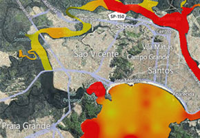

USP researchers develop application to facilitate and accelerate licensing of new undertakings and operations in the coastal area due to exploration of the Pre-Salt fields and duplication of cargo capacity at the Port of Santos
USP researchers develop application to facilitate and accelerate licensing of new undertakings and operations in the coastal area due to exploration of the Pre-Salt fields and duplication of cargo capacity at the Port of Santos.
USP researchers develop application to facilitate and accelerate licensing of new undertakings and operations in the coastal area due to exploration of the Pre-Salt fields and duplication of cargo capacity at the Port of Santos.

USP researchers develop application to facilitate and accelerate licensing of new undertakings and operations in the coastal area due to exploration of the Pre-Salt fields and duplication of cargo capacity at the Port of Santos
By Elton Alisson
Agência FAPESP – The Santos Basin (SP) is expected to receive a series of investments due to the beginning of exploration operations of the Pre-Salt basin and the duplication of cargo handling capacity at the Port of Santos.
A geotechnology tool developed in the Geoprocessing Lab run by the Transportation Engineering Department at Universidade de São Paulo’s Polytechnic School facilitates and accelerates decision making for licensing new undertakings or operations in the region’s coastal area.
Still under development, the so-called “Environmental and Socioeconomic Atlas of the Santos Basin” began being compiled in 2006 through FAPESP funding under the Public Policy Research Program. Currently, in order to evaluate the impact of building an undertaking or beginning an industrial or port operation (dredging, for example) in marine coastal zones, public managers utilize a series of digital or print reports with an enormous array of data, surpassing 15 volumes, which do not have a clear connection among their respective topics.
To facilitate and accelerate this process, the researcher developed an Atlas based on thematic maps, associated with a georeferenced database of the coastal area on the Santos Basin. The tool, which also seeks to improve the work of public managers, integrates information on the environment, cultural use and socioeconomic data on the region in a single, easy access platform that is written in simple language.
Through the Portal, users can access tables, graphs, videos and maps of a given area in the region where s/he intends to build a new undertaking. By crossing maps on the different topics of interest, it is possible to evaluate whether the ecosystem supports a given construction project.
“It is possible, for example, to click on a given region of the map to know the level of contaminants and verify if it is above or below the limit established by Cetesb [Companhia de Tecnologia de Saneamento Ambiental, the environmental agency overseeing such projects],” explains Silvia Sartor, coordinator of the project in an interview with Agência FAPESP.
According to her, the environmental and socioeconomic management tool is unprecedented and can be applied in any area, even if it doesn’t deal with the marine coastal area. Before developing it, Sartor participated in construction of the Atlas of Environmental Sensitivity to Oil in the Santos Maritime Basin for Petrobras and the Environment Ministry.
Through this experience, the researcher found out firsthand how difficult it can be to obtain data from previous research projects, not to mention the fragmentation and the lack of availability and standardization of information about the coastal zone of the Santos Basin.
“Since there is not a company interested in studying the São Vicente Canal, for example, which is an area that is not industrialized, there is an enormous lack of data about that region,” she says. “The only available previous study on the Port of Santos Navigation Canal and macrobenthos, a group of fauna that is an indicator of environmental impact, was conducted in 1979. A new study was completed from 2006-2008 to support research aimed at evaluating the environmental impact of deepening the Port of Santos, which totaled 19 volumes,” she cites as an example.
Thematic maps
Based on the experience, Sartor decided to undertake an environmental and socioeconomic impact evaluation in a broader region with more simplified language to better allow public managers to visualize ecological indicators before making decisions on the approval or denial of new construction projects or operations in the region.
To this end, she formed partnerships with public organs like the Environment Ministry, the Brazilian Environment and Renewable Natural Resources Institute (Ibama) and Cetesb, which provided data, and the companies Imagem Soluções Espaciais and Esri, which supplied the software to generate thematic maps.
Sartor also relied on researchers from several areas, including biology, ecology, oceanography, human sciences and computation to interpret and standardize the data.
“Each theme on the map required the involvement of a specialist in the area to define standards that allow data from different studies to be compared. And that is very complex,” she explains.
Currently, the group is developing a site on the internet to facilitate access to data and is seeking sponsorship for the next stages of the project. “The tool is already in a phase of development that allows for demonstration of its capacity to licensing agencies such as Ibama and Cetesb. We hope to draw these agencies’ attention to the efficacy of the tool in accessing and visualization of information, prompting them to demand that new Environmental Impact Studies or Environmental Impact Reports, prepared by companies interested in licensing their undertaking in the region, are developed in this new format,” says Sartor.
Republish
The Agency FAPESP licenses news via Creative Commons (CC-BY-NC-ND) so that they can be republished free of charge and in a simple way by other digital or printed vehicles. Agência FAPESP must be credited as the source of the content being republished and the name of the reporter (if any) must be attributed. Using the HMTL button below allows compliance with these rules, detailed in Digital Republishing Policy FAPESP.


