


Survey under way seeks to help ensure earthquake-resistant construction becomes more widespread (photo: Bento Rodrigues, Mariana, MG / Antonio Cruz / Agência Brasil)
Survey under way seeks to help ensure earthquake-resistant construction becomes more widespread.
Survey under way seeks to help ensure earthquake-resistant construction becomes more widespread.
Survey under way seeks to help ensure earthquake-resistant construction becomes more widespread (photo: Bento Rodrigues, Mariana, MG / Antonio Cruz / Agência Brasil)
By Elton Alisson, in Belo Horizonte (Minas Gerais) | Agência FAPESP – Researchers at the University of São Paulo’s Institute of Astronomy, Geophysics & Atmospheric Sciences (IAG-USP), in collaboration with colleagues at São Paulo State University (UNESP), Rio Claro campus, the Federal University of Rio Grande do Norte (UFRN), the University of Brasília (UnB), the National Observatory and Fundação Getúlio Vargas in Rio de Janeiro (FGV-RJ), are working on a new national map of seismic hazards for Brazil.
A preliminary version of the seismic hazard map was presented by Marcelo Sousa de Assumpção, a professor at IAG-USP and one of the coordinators of the Brazilian Seismographic Network (RSBR), on July 19 during the 69th Annual Meeting of the Brazilian Society for the Advancement of Science (SBPC). Assumpção is the principal investigator for a Thematic Project supported by FAPESP.
Entitled “Innovation – Diversity – Transformations”, the SBPC conference was held from July 16th to the 22nd on the Pampulha campus of the Federal University of Minas Gerais (UFMG) and was attended by researchers from Brazil and abroad, as well as managers of the National Science & Technology System (SNCT).
“Seismic risk is relatively low in Brazil compared with other South American countries, such as Chile or Peru, thanks to its location in a stable region with very old topography and in the interior of a tectonic plate,” Assumpção said. “But low-and medium-intensity tremors occur with a certain frequency in Brazil, and these can have drastic consequences depending on where they happen.”
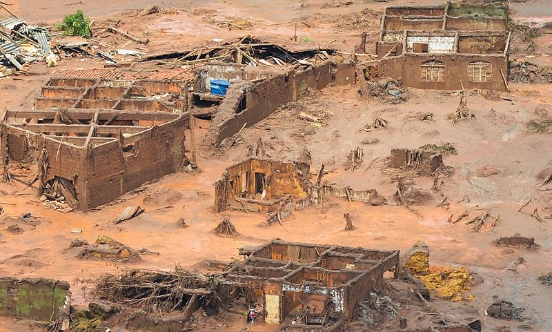
According to him, a recent example was the series of tremors of magnitudes 2.01-2.55 that occurred in Mariana, Minas Gerais state, three days before the collapse of the Fundão tailings dam owned by Samarco, resulting in the worst environmental disaster in Brazilian history.
Despite its low magnitude, the epicenter of a 2.5 tremor occurred only 1 km from the tailings dam, according to a statement by Samarco in a report on the causes of the accident prepared by an international committee of experts that analyzed the dam geotechnically.
One of the committee’s conclusions was that low-magnitude tremors cannot endanger well-built structures that are in use. “This dam, however, was in a fragile condition, and the tremors occurred an hour before it burst,” Assumpção said.
Probability
In preparing the seismic hazard map, the researchers first conducted a survey of the tremors that have occurred in Brazil in recent decades in order to determine the level of seismic activity in each region.
According to the survey, seismic events occur most frequently in the Northeast, especially in the states of Ceará and Rio Grande do Norte, in northern parts of Mato Grosso and Goiás states, and in Mato Grosso state's wetlands (Pantanal biome).
“Actually, any region is susceptible to seismic tremors. The probability is higher in some areas, such as Minas Gerais, and lower in others. We don’t yet know exactly why some areas are more active than others,” Assumpção said.
Based on the frequency and magnitude of these tremors, they estimated the probability of similar tremors in the coming years and the level of vibration they would cause in the soil on which homes, hospitals, stores and other buildings stand, given their distance from the epicenter.
Magnitude 3 tremors, for example, occur twice per month on average in Brazil. Magnitude 4 tremors, such as the 2012 quake in Montes Claros, Minas Gerais, occur twice a year. Magnitude 5 tremors, such as the quake that hit the town of Itacarambi in Minas Gerais in 2007, cause damage and occur once every 50 years, according to the researchers.
“The tremors that occurred before the collapse of Samarco’s tailings dam in Mariana, for example, occur all the time and are felt only when they occur near a town or city,” Assumpção said.
“Although seismic events of this magnitude are relatively low-level, if they occur 1 km from a building or in the middle of a town, their intensity can be substantial, and they can have a serious impact on the population.”
He added that Brazil’s seismic-resistant building standard, NBR-15421, in force since 2006, was based on an outdated seismic hazard map.
“We believe Brazil has many more earthquake-prone areas than are identified by the old map on which the standard was based,” he said.
Builders of hydroelectric dams are required to perform seismic hazard studies before their designs are approved.
In the case of tailings dams, many mining companies perform seismic hazard studies as part of the design process to make sure they can withstand a major earthquake, but not all do so, according to Assumpção.
“There were no regulations that required seismic studies for approval of tailings dams,” he said.
The Agency FAPESP licenses news via Creative Commons (CC-BY-NC-ND) so that they can be republished free of charge and in a simple way by other digital or printed vehicles. Agência FAPESP must be credited as the source of the content being republished and the name of the reporter (if any) must be attributed. Using the HMTL button below allows compliance with these rules, detailed in Digital Republishing Policy FAPESP.
