
Model could be utilized for production of more detailed maps and for major engineering works
Model could be utilized for production of more detailed maps and for major engineering works.
Model could be utilized for production of more detailed maps and for major engineering works.

Model could be utilized for production of more detailed maps and for major engineering works
By Elton Alisson
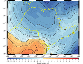
Agência FAPESP – The topographic relief of São Paulo has gained more definition after researchers from the Universidade de São Paulo’s Polytechnic School (Poli-USP) concluded the development of a more precise geoid model of São Paulo State.
Developed under the auspices of a FAPESP Thematic Project, the model will be useful in the production of more detailed maps of the state and the construction of large engineering works such as roads, hydroelectric plants, sewage networks and irrigation, for example.
“The geoid model will facilitate measurements of variations in altitudes in São Paulo State with high accuracy, which are essential for several applications in engineering,” said João Francisco Galera Monico, professor at the Universidade Estadual Paulista (Unesp) at its Presidente Prudente campus and coordinator of the Thematic Project.
The model is based on the measures of acceleration of the gravity of soil. The factor varies subtly at each point on Earth, based on the relief and density of interior rocks, and determines the level and direction of the waters of rivers and oceans.
Because of this, the model provides important information for major engineering works that involve the use of water and complements the relief measures conducted through the Global Navigation Satellite System (GNSS).
Utilized to handle leveling works, the GNSS satellites in operation around the world, such as GPS in the United States and Glonass in Russia, provide data on geometric altitudes.
According to Monico, although the data are very important, this type of vertically calculated altitude does not take into account the physical size of a given region when measuring the variation of the relief, such as its mass, which is directly proportional to the acceleration of gravity. The geoid model calculates the altitude on Earth horizontally and takes into account the physical size and the course of river and ocean waters that move through the region in estimating altitude.
By combining these two different measures of altitude provided by the geoid model and GNSS, it was possible to obtain a third altitude, the so-called leveled height, which represents the physical size of a given region.
In this manner, it is possible to obtain maps of an area in which, for example, the building of a hydroelectric plant is planned, with differences in the elevation of the soil characterized with much more accuracy than the relief measurements obtained from geometric leveling conducted in the past.
Obtained using equipment known as levels, each measurement indicates the variations of relief over distances of approximately 100 meters, covering a few kilometers per day.
“Leveling for construction of a hydroelectric plant, for example, is a slow and expensive process,” explained Monico. “The geoid model eases the use of GNSS in this activity and affords quicker relief measurement with lower risk of error of misappropriation of properties in areas that will be affected by the project.”
According to the researcher, this way of measuring variations with respect to associated heights in the field of gravity will also allow for geological mapping for construction of highways, irrigation and sewage.
Furthermore, the model will help in identification of oil reserves, mineral deposits and unexplored caverns, showing how and when the quantity of underground water deposits in large aquifers oscillates throughout the year.
“The greater the accuracy of the relief measurements, the greater the facility for several applications,” affirmed Monico.
Construction of the model
The development of the geoid model of São Paulo State is part of the doctoral research of Gabriel do Nascimento Guimarães at Poli – USP, under the supervision of Professor Denizar Blitzkow.
To develop the model, the scientists collected gravimetrics from different points in São Paulo and the surrounding states, including Minas Gerais, Mato Grosso do Sul and Paraná.
The data were complemented by satellite information from the Gravity Recovery and Climate Experiment (Grace),operated by NASA, the German Space Agency DLR and GOCE of the European Space Agency.
The model was compared to leveling observations in São Paulo State conducted using GPS and GOCE. The comparison revealed that the model and the leveling conducted using satellites yield results that differ by a mere 20 centimeters.
“We can affirm that today, the geoid model in São Paulo State has 20-centimeter consistency with leveling conducted by GNSS. This represents the best performance in Brazil, which, on average, varies by some 50 centimeters,” said Guimarães.
When professor Blitzkow began to measure variations in gravity and develop geoid models in the 1980s, the difference in leveling was 5 meters.
He attributes the reduction in the difference to several factors, such as the efforts of the Brazilian Geography and Statistics Institute (IBGE) to produce maps of the variation in the gravity field throughout Brazil. Another factor was missions such as that conducted with GOCE, which mapped the Earth’s gravity to an unprecedented level of detail.
“In 1980, when we began to measure gravity, we began to improve the consistency of geoid models in Brazil by meters. Today, we are improving centimeter by centimeter,” said Blitzkow during the third workshop on the Thematic Project, held on June 20 during the MundoGEO#Connect Latin America 2013 conference.
Republish
The Agency FAPESP licenses news via Creative Commons (CC-BY-NC-ND) so that they can be republished free of charge and in a simple way by other digital or printed vehicles. Agência FAPESP must be credited as the source of the content being republished and the name of the reporter (if any) must be attributed. Using the HMTL button below allows compliance with these rules, detailed in Digital Republishing Policy FAPESP.


