


The BDC-Favelas Explorer is expected to be available for consultation by the end of 2026 (image: CEFAVELA)
Brazil Data Cube-Favelas, a partnership between the National Institute for Space Research and CEFAVELA, a FAPESP RIDC, will provide access to large volumes of data. An article on the technology won an award at the Applied Computing Workshop.
Brazil Data Cube-Favelas, a partnership between the National Institute for Space Research and CEFAVELA, a FAPESP RIDC, will provide access to large volumes of data. An article on the technology won an award at the Applied Computing Workshop.
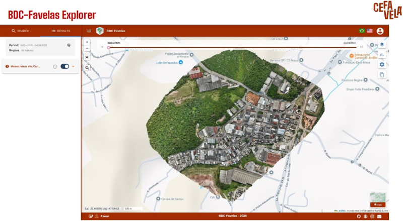
The BDC-Favelas Explorer is expected to be available for consultation by the end of 2026 (image: CEFAVELA)
Agência FAPESP* – The Center for Favela Studies (CEFAVELA) and the National Institute for Space Research (INPE), both in Brazil, presented the first proof of concept for the BDC-Favelas Explorer platform at the Applied Computing Workshop (WorCAP). WorCAP is an annual event organized by the INPE’s Graduate Program in Applied Computing. The article presenting the study won the award for best work in the Senior category at the event.
CEFAVELA is a Research, Innovation, and Dissemination Center (RIDC) funded by FAPESP. It is based at the Center for Engineering, Modeling, and Applied Social Sciences at the Federal University of ABC (CECS-UFABC) in São Bernardo do Campo in the São Paulo Metropolitan Area (SPMA).
The article, entitled “BDC-Favelas Explorer: Web portal for accessing and disseminating information about favelas based on Earth observation data”, was written by Fabiana Zioti Vieira, a researcher at the INPE and a FAPESP scholarship recipient.
The BDC-Favelas project is based on the Brazil Data Cube (BDC) platform. This scientific and technological project, developed by the INPE, produces data from large volumes of medium-resolution remote sensing images of the entire national territory. As part of the project, INPE researchers are developing a computational platform to process and analyze this data using artificial intelligence, machine learning, and image time series analysis.
BDC-Favelas incorporates high-resolution spatial and temporal data, develops strategies to generate favela indicators, and creates a data science environment that integrates local knowledge using machine learning techniques. The platform is being developed to address the lack of accurate, accessible information regarding the size, location, and temporal evolution of precarious settlements.
However, the production of information on favelas faces limitations, including a lack of data ready for analysis, difficulty integrating multiple sources (e.g., satellite images and drone data), and the need for accessible interfaces for various audiences, such as researchers, managers, and residents.
“Orbital remote sensing and drone data offer opportunities to fill this gap, but there’s a lack of platforms that integrate and make this data available efficiently,” says Flávia Feitosa, principal investigator at CEFAVELA.
Geospatial data platform
The BDC-Favelas project aims to develop a national geospatial data platform that focuses on favelas and low-income areas. The data will be made available via the BDC-Favelas Explorer web portal, ensuring open and free access. The platform will incorporate new data and mosaics with higher spatial and temporal resolutions. This will include open remote sensing data collections, high-resolution images obtained by drones, and new data sets integrated into the cube as grids.
One unique feature of the BDC-Favelas project is its incorporation of drone-obtained data. Because drones have a scale of centimeters, they allow for more detailed information on favela territories. Due to their dense construction, satellite images often fail to capture details that can be obtained by flying a drone overhead. However, it is not possible to use drones in all areas, so this data collection complements the remote sensing images obtained by the BDC.
For the WorCAP presentation, researchers from CEFAVELA and the INPE involved in the BDC-Favelas Explorer project tested the integration of data collected from drone flights in Jardim Zaíra and Vila Carlina, two areas in Mauá, a city in the SPMA.
The flights validated the system’s functionality with real data and established protocols and procedures for data processing and information dissemination. BDC-Favelas Explorer is expected to be available for consultation by the end of 2026.
The article about the project can be read at zenodo.org/records/17186759.
* With information from Janaína Simões from CEFAVELA
The Agency FAPESP licenses news via Creative Commons (CC-BY-NC-ND) so that they can be republished free of charge and in a simple way by other digital or printed vehicles. Agência FAPESP must be credited as the source of the content being republished and the name of the reporter (if any) must be attributed. Using the HMTL button below allows compliance with these rules, detailed in Digital Republishing Policy FAPESP.
