





By José Tadeu Arantes | Agência FAPESP – Accurately predicting the path of a storm and the intensity of rainfall for the next 30 minutes no longer requires the use of supercomputers. TITAN-LSTM, a new tool developed at the University of São Paulo (USP) in Brazil, combines weather radar data with artificial intelligence to make very short-term forecasts. It tracks and updates the path, area, and intensity of precipitation every five minutes. The system stands out for its low computational cost, which makes it easy to implement in regions that already have radar coverage.
Andrea Salomé Viteri López, a postdoctoral researcher at the Institute of Astronomy, Geophysics, and Atmospheric Sciences (IAG-USP), conducted this work with support from FAPESP. The results were published in the Journal of Geophysical Research: Machine Learning and Computation. IAG professor Carlos Augusto Morales Rodriguez, López’s advisor during her doctoral studies, is also an author of the article.
“Our goal was to make a very short-term rainfall forecast using TITAN, an algorithm capable of identifying individual storms. With it, we were able to calculate characteristics such as area, intensity, direction, and propagation speed. We then used that information in a neural network to predict how the storm would evolve,” López explains.
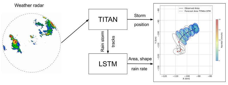 The radar provides rainfall estimates.TITAN identifies and tracks the storm; its characteristics continuously feed the LSTM. The predictions from both components are combined. The system produces a storm projection for the next 5 to 30 minutes.
The name of the new tool reflects its combination of two generations of technology. On the one hand, there is TITAN (an acronym for Thunderstorm, Identification, Tracking, Analysis, Nowcasting), a classic 1990s algorithm that specializes in tracking clouds on radar. The other is LSTM (Long Short-Term Memory), a type of artificial intelligence designed to memorize sequences of events over time.
You can think of the division of tasks as follows: TITAN tells us where the storm is, where it came from, and where it is going. The LSTM network seeks to answer another question: Given what has happened to the storm in the last few minutes, what will it be like shortly?
This distinction is important because a storm is not a rigid object that simply moves through space. As it moves forward, it grows or shrinks, intensifies or weakens, changes shape, and eventually dissipates. Traditional extrapolation methods excel at tracking movement but struggle to represent these transformations. More sophisticated neural networks can learn these transformations. However, many of these networks work directly with successive two-dimensional radar images. This requires large databases, preprocessing of the images, and high computational power.
“TITAN-LSTM aims to strike a balance. Instead of feeding the entire radar image to the artificial intelligence, TITAN transforms each storm into a sequence of numerical data: area covered by rain, precipitation volume, average and maximum intensity, storm dimensions, direction and speed of movement, among other factors. The neural network then learns how those characteristics change over time. And in that way, it can predict their future evolution,” says the researcher.
A network that retains what matters
The fundamental characteristic of LSTM is its selective memory. As it receives a sequence of data, the network learns which previous information remains relevant and which can be discarded. This is technically done through mechanisms called “gates,” which regulate the input, retention, and output of information from the network’s memory.
López uses this very image to explain how it works. “They’re like decision gates. At each stage, the network decides whether the information is relevant or not and whether it should be retained or discarded. During training, the weights are adjusted, and as new data sequences are received, the internal memory is updated to produce the next predictions,” she explains.
This allows the system to consider not only a snapshot of a storm, but also its recent history. Tests have shown that this memory makes a difference; the more data on a storm’s evolution that is provided to the network, the better the forecast tends to be.
More than 32,000 storms tracked
To develop the system, the researchers used data collected from 2016 to 2019 by the weather radar installed at the Ponte Nova dam in Biritiba Mirim. This town is one of the 39 municipalities that comprise the São Paulo Metropolitan Region (RMSP). The equipment performs a new scan every five minutes. For the study, they considered an area with a radius of 120 kilometers around the radar.
To train the artificial intelligence, the system initially analyzed more than 32,000 storms. However, it was necessary to apply “strict criteria to select events whose entire progression could be tracked,” López explains. This meant isolating only rainstorms that lasted more than 20 minutes and did not merge with other clouds. From this refined selection, 439 storms remained. From this select group, the researcher reports that “307 were used to train the neural network, and 132 were kept separate to test its predictive ability.”
The analysis of these events revealed interesting aspects of their dynamics. Approximately 70% of the storms occurred between November and March, and about 83% lasted between 20 and 40 minutes. The shortest storms reached their maximum extent around the 15-minute mark. Intermediate storms lasting 40 to 60 minutes peaked between 25 and 30 minutes. Long storms persisting for more than an hour reached their peak area at around 40 to 45 minutes. These growth and dissipation curves are precisely the type of temporal pattern that an LSTM can learn.
Tests confirmed that the new system outperforms the traditional method by more than three times in predicting the exact area of rainfall right from the start. “The results showed a significant advantage of the hybrid approach,” the researcher notes. This numerical leap is evident in the accuracy rate, which rose from 0.2 to approximately 0.7 within the first few minutes, “while false alarms were reduced by nearly 70%,” López explains.
As expected, uncertainty increases the further into the future one tries to look. The error margin for estimating rainfall intensity was about 3 millimeters per hour for a five-minute forecast, increasing to approximately 3 to 4 millimeters per hour at the 30-minute mark. Nevertheless, providing the network with a longer history of the storm greatly reduced errors in predicting the area of rainfall.
There is also an important practical advantage. Training the entire configuration used in the study, which included 439 storms, took approximately 20 minutes on a conventional computer using programs written in Python. Python is widely used in data science, machine learning, and artificial intelligence.
Unlike many deep learning architectures, which process large sequences of images and require high-performance units, TITAN-LSTM primarily works with time series of values extracted from storm tracking data. “One advantage is that we don’t need supercomputers,” the researcher notes. “The software can be installed on any laptop. And, as long as the specifications of the radar being used are taken into account, the algorithm can be adapted."
This feature paves the way for an application that goes beyond meteorological research. Predicting where a storm will be in five, ten, or 15 minutes, the area it will cover, and how intense the rainfall will be can provide useful information for flood warning systems and Civil Defense.
“Civil Defense requires very rapid forecasts. If we know where the rain is passing through, how intense it’ll be, what area it’ll cover, and where it’s headed, we can assess which regions will be affected. The goal is to aid in decision-making, such as closing roads or evacuating people from high-risk areas,” López emphasizes.
This information can also be used to inform hydrological models. Knowing the amount of rain that may fall in a given watershed and the speed at which a storm moves allows us to estimate the risk of rapid increases in river flow, flooding, and inundation well in advance.
New development
TITAN-LSTM currently focuses on a specific category of storms: “continuous” storms. These storms can be tracked as a single entity throughout their life cycle without merging with other storms or splitting into different cells. This restriction was deliberately adopted during the initial development stage of the method. “Now, we’re working on complex storms. These are storms that can merge with others or split into multiple storms as they evolve,” the researcher explains.
According to López, the goal is for the tool to adapt to other radars and, eventually, provide forecasts to agencies responsible for issuing alerts and disaster prevention. Its relative computational simplicity is crucial in this regard. “The idea is to make the tool available for download on any laptop and enable it to link to other radars in other parts of Brazil,” she says.
The new ongoing research is also funded by FAPESP.
The article “TITAN-LSTM: A weather radar nowcasting tool” can be accessed at https://agupubs.onlinelibrary.wiley.com/doi/full/10.1029/2026JH001337.
Republish
The Agency FAPESP licenses news via Creative Commons (CC-BY-NC-ND) so that they can be republished free of charge and in a simple way by other digital or printed vehicles. Agência FAPESP must be credited as the source of the content being republished and the name of the reporter (if any) must be attributed. Using the HMTL button below allows compliance with these rules, detailed in Digital Republishing Policy FAPESP.
