


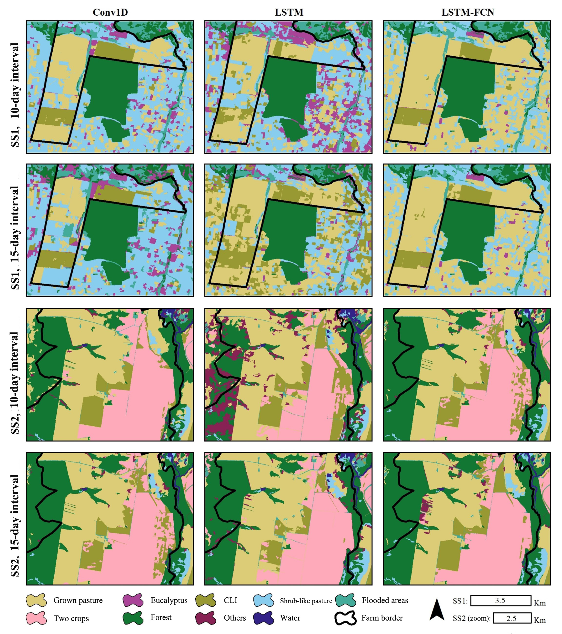
Final thematic maps of land cover and use in the study sites — Fazenda Campina in São Paulo (SS1) and Fazenda Gravataí in Mato Grosso (SS2) — showing results of deep learning and analysis of time series (credit: Inácio Thomaz Bueno)
The study, which was conducted by Brazilian researchers, supports sustainable agriculture and offers contributions to public policy formulation.
The study, which was conducted by Brazilian researchers, supports sustainable agriculture and offers contributions to public policy formulation.
Final thematic maps of land cover and use in the study sites — Fazenda Campina in São Paulo (SS1) and Fazenda Gravataí in Mato Grosso (SS2) — showing results of deep learning and analysis of time series (credit: Inácio Thomaz Bueno)
By Thais Szegö | Agência FAPESP – Crop-livestock integration (CLI) systems combine the growing of crops in rotation or consortium, especially grain crops such as soybeans, corn and sorghum, and forage plants used to feed cattle and pigs, with the raising of livestock, typically beef cattle. The crops provide most of the cash income, while the livestock has food available during the dry season and facilitates seed management. CLI improves soil fertility, raises yields and helps rehabilitate degraded areas while reducing the use of pesticides, mitigating the risk of erosion and the seasonality of production, and lowering operating costs. It makes farming more sustainable: crops benefit livestock and vice-versa; the environmental impact of agricultural activity falls; and the carbon footprint is reduced.
In a study reported in the journal Remote Sensing of Environment, researchers affiliated with the Brazilian Agricultural Research Corporation (EMBRAPA) and the State University of Campinas (UNICAMP) developed a method based on artificial intelligence (AI) to identify CLI areas by analyzing satellite imagery. According to the authors of the article, this knowledge can benefit Brazilian agriculture in several ways.
The study was funded by FAPESP via three projects (2021/15001-9, 2018/24985-0 and 2017/50205-9), and by the Netherlands Organization for Scientific Research (NWO).
“The main aim of the project, which was an international collaboration to address issues relating to sustainable agriculture, was to promote the integration of remote sensing data with satellite images using AI, precision agriculture and biogeochemical models to understand and create models of the dynamics of this type of system,” said Inácio Thomaz Bueno, first author of the article. A forest engineer, Bueno conducted postdoctoral research on the monitoring of CLI systems using remote sensing data and satellite imagery with high spatio-temporal resolution.
“We also aimed to increase knowledge of CLI, given the many questions still open and the lack of effective methods for monitoring and development of its potential, as well as the need to identify areas in which it’s being practiced, in line with the UN’s Sustainable Development Goals [SDGs] relating to agriculture, the environment, and economic and social development,” he said.
The team used deep learning techniques to process satellite imagery time series and extract patterns pointing to areas where CLI was being practiced. Deep learning is a type of AI that uses neural networks with multiple layers to model and process complex patterns in data.
The study sites were areas in the states of São Paulo and Mato Grosso. Object-based image analysis was performed at intervals of 10 and 15 days in four steps: CLI data acquisition via Planetscope, a constellation of satellites that capture high-resolution images of Earth’s surface, showing changes in the areas over time; training of algorithms to recognize patterns associated with CLI; mapping of CLI areas; and assessment of the model’s accuracy by comparing automatic results with previous knowledge.
For Bueno, the promising results obtained by this method, which involved monitoring and mapping CLI areas via satellite images and analyzing their dynamics over time, can have various kinds of positive impacts on agriculture. “Precise identification of CLI areas permits more efficient resource management to optimize land allocation and use. In addition, diversification of activities offers farmers an additional source of income,” he said.
The detailed information derived from CLI mapping also provides a sound basis for decision-making by farmers, who can feel confident that their crop-livestock management and investment policies are grounded in science.
Another benefit of the approach is that it encourages sustainable agriculture. Recognition and mapping of CLI areas can support government policies and programs to promote sustainable practices, contributing to regularity of food supply and income via financial incentives and specific lines of credit that support the adoption of integrated systems.
The article “Mapping integrated crop-livestock systems in Brazil with PlanetScope time series and deep learning” is at: www.sciencedirect.com/science/article/abs/pii/S0034425723004376.
The Agency FAPESP licenses news via Creative Commons (CC-BY-NC-ND) so that they can be republished free of charge and in a simple way by other digital or printed vehicles. Agência FAPESP must be credited as the source of the content being republished and the name of the reporter (if any) must be attributed. Using the HMTL button below allows compliance with these rules, detailed in Digital Republishing Policy FAPESP.
