


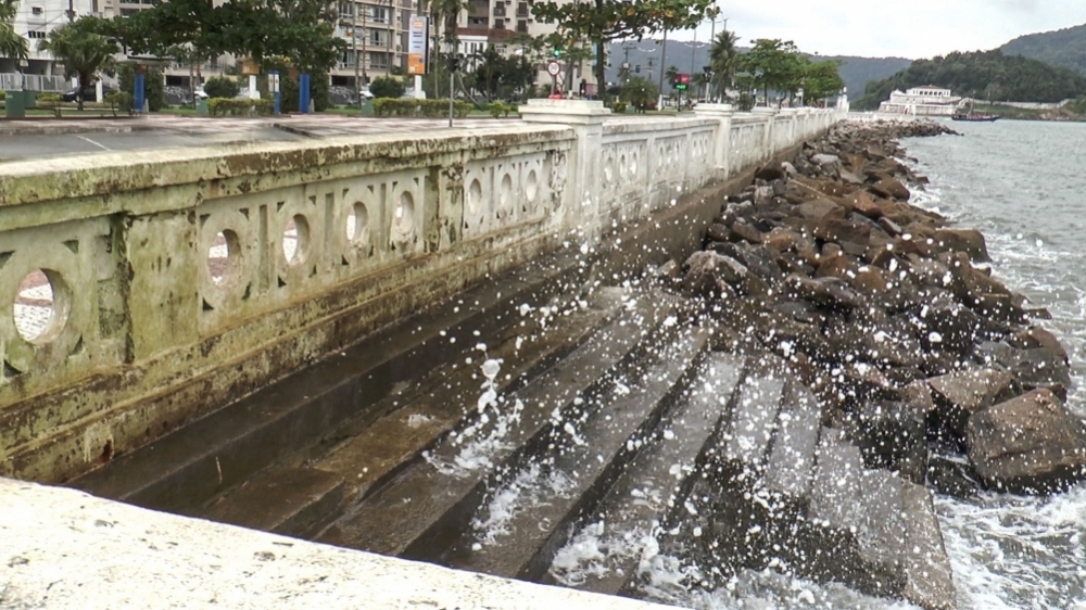
Economic losses due to rising sea levels and storm surges associated with extreme weather events could reach almost R$2 billion in São Paulo State's most important port city unless adaptive measures are implemented, according to an international study (photo: Leandro Negro/Agência FAPESP)
Economic losses due to rising sea levels and storm surges associated with extreme weather events could reach almost R$2 billion in São Paulo State's most important port city unless adaptive measures are implemented.
Economic losses due to rising sea levels and storm surges associated with extreme weather events could reach almost R$2 billion in São Paulo State's most important port city unless adaptive measures are implemented.
Economic losses due to rising sea levels and storm surges associated with extreme weather events could reach almost R$2 billion in São Paulo State's most important port city unless adaptive measures are implemented, according to an international study (photo: Leandro Negro/Agência FAPESP)
By Elton Alisson, in Santos
Agência FAPESP – Coastal flooding in the southeastern and northwestern areas of Santos, a port city in São Paulo State, Brazil, due to a combination of rising sea levels, swells and heavy surf, meteorological and astronomical tides, and extreme weather events, could cause damage amounting to almost R$2 billion by 2100 unless adaptive measures are taken.
The estimate is from an international study by Brazilian researchers at the Natural Disaster Surveillance & Early Warning Center (CEMADEN), the National Space Research Institute (INPE), the Geological Institute (IG), the University of São Paulo (USP) and the University of Campinas (UNICAMP), in partnership with colleagues at the University of South Florida (USA) and King’s College London (UK), as well as technical staff employed by the City of Santos.
The results of the study, which is part of the project “An integrated framework to analyze local decision making and adaptive capacity to large-scale environmental change: community case studies in Brazil, UK and US” supported by FAPESP under a cooperation agreement with the Belmont Forum, were presented on September 30 to representatives of civil society in Santos.
During the meeting, the researchers showed local leaders their projections for sea level rises and their economic impact by 2050 and 2100 on the southeastern and northwestern areas of Santos, which are already affected by a rise in sea levels and extreme events. The idea was for participants to discuss possible adaptive measures to minimize risks.
“It isn’t necessary to wait 20 or 30 years to feel the effects of rising sea levels. Adaptive measures can be implemented right now in order to minimize the potential economic damage,” said José Marengo, CEMADEN’s head researcher and coordinator of the project on the Brazilian side, in an interview given to Agência FAPESP.
Using data on sea level changes in Santos obtained from a tide gauge network in the region for the period 1945-1990 and satellite altimetry for 1993-2013, the researchers found that the sea level there has risen an average of 3 mm per year in recent years.
Based on this finding, they estimated that the sea level in the city’s coastal areas may rise between 18 and 30 cm by 2050 and between 36 cm and 1 m by 2100.
Given the rise in average sea levels, the occurrence of swells, high breakers, surges, meteorological tides and phases of spring or syzygy tides (high tides influenced by extra gravitational pull due to the alignment of the sun, moon and earth) could lead to an even faster rise in sea levels, which could reach 90 cm by 2050 and 95 cm by 2100.
In these conditions, southeastern and northwestern Santos would be even more flooded by the sea, and shore erosion would increase.
“The Santos coastal plain has very mild slopes – less than 2% – with elevations of less than 3 m. In addition, the water table in the city is very shallow, making it highly vulnerable to flooding by both sea swells and heavy rain,” said Joseph Harari, a professor at the University of São Paulo’s Oceanography Institute (IO-USP) and also one of the researchers on the project.
Increase in storm surges
The impact of higher sea levels, combined with meteorological and astronomic tides and weather events, has been felt in Santos for a few decades.
A study by Celia Regina de Gouveia Souza, a researcher at the São Paulo State Geological Institute and also a participant in the project, showed that the number of floods due to storm surges or heavy swells recorded in Santos has risen sharply since the late 1990s.
The number was 15 in 2010, for example, up from a maximum of four per year between 1960 and 1991.
The worst storm surge recorded in Santos occurred in 2005 and led city hall to build a rock armor revetment at the end of Ponta da Praia, a headland that has suffered rapid shoreline erosion since the early 1940s, when a boulevard was built along the sea front.
Storm surges in the area are associated with extratropical cyclones, Souza explained. These form at the southernmost tip of South America and travel up to Brazil’s Southeast region, generating high-energy waves and storm tides (abnormal rises in sea level above normal astronomical tides) as well as cold fronts that are often accompanied by heavy rain in coastal areas.
“The rising sea levels due to all these factors combined are having an increasingly intense impact on the shoreline, but we don’t know whether the magnitude of the events has changed,” Souza said.
The northwestern part of the city, for example, is frequently flooded by the sea during surges and exceptionally high tides and also by heavy rain. Some 83,000 people live in the area, where property values are lower than in Ponta da Praia.
The southeastern part, with some 34,000 inhabitants and the city’s highest property values, is affected by regular flooding due to heavy rain and above all by shore erosion, which is steadily worsening in Ponta da Praia.
“Land tenure and use patterns differ in these two areas, so their vulnerability to sea level rises also varies, and the potential damage and losses differ as well,” Souza said.
Calculation of losses
The researchers estimated the possible economic damage due to coastal flooding in southeastern and northwestern Santos caused by sea level rises projected under scenarios for 2050 and 2100, combined with storm tides of 1.60 m in 2050 and 1.66 m in 2100 resulting from extreme events normally predicted to occur once every 100 years.
The projections were calculated using a geoprocessing software platform called COAST (Coastal Adaptation to Sea Level Rise Tool), developed by a US-based company.
The software predicted the likely dollar damage to economic assets, such as buildings, in a given period due to flooding caused by varying amounts of sea level rise, as well astronomical and meteorological tides. This information was combined with georeferenced spatial data and property values supplied by the City of Santos.
The projections showed that the southeastern portion of the city will be the most affected under all three scenarios of sea level rises calculated for 2050 and 2100.
Under a “business-as-usual” scenario, assuming no adaptive measures are taken to prepare for a 1 m rise by 2100 (the worst-case hypothesis), the economic damage could reach R$1.3 billion in southeastern Santos and R$483.8 million in the city’s northwestern area, according to the researchers.
“At present, COAST and other mathematical models can’t estimate the resilience and resistance of environments, such as how a shoreline responds to rising sea levels, for example, or how far mangroves can delay encroachment of estuarine areas by the ocean,” Souza said.
“In any event, adaptive measures must be studied and implemented to minimize the potential socio-economic impact.”
The adaptive measures that are being taken around the world to mitigate the flooding and shore erosion caused by rising sea levels include natural barriers, such as mangroves in Palm Beach, Florida; beach nourishment in Cuba and Miami, Florida; mobile dikes in Venice, Italy; and revamped home and building designs for resilience to sea encroachment in Hamburg, Germany.
In Santos, the participants in the workshop discussed and recommended a number of adaptive measures considered appropriate for the city.
The proposals will be incorporated into the COAST system and evaluated by the researchers in the next two months.
The measures considered most feasible in terms of cost and timing will be presented at a workshop scheduled for December 1.
“Adaptation is a costly process. But the cost of doing nothing is far higher,” Marengo said.
Read more about the project at agencia.fapesp.br/22041.
The Agency FAPESP licenses news via Creative Commons (CC-BY-NC-ND) so that they can be republished free of charge and in a simple way by other digital or printed vehicles. Agência FAPESP must be credited as the source of the content being republished and the name of the reporter (if any) must be attributed. Using the HMTL button below allows compliance with these rules, detailed in Digital Republishing Policy FAPESP.
