


App suitable for smartphones and tablets will enable any user to access forecasts (figure: propagation of lightning in different directions / researcher's archive)
App suitable for smartphones and tablets will enable any user to access forecasts.
App suitable for smartphones and tablets will enable any user to access forecasts.
App suitable for smartphones and tablets will enable any user to access forecasts (figure: propagation of lightning in different directions / researcher's archive)
By José Tadeu Arantes | Agência FAPESP – A model designed to forecast the occurrence of lightning during storms is being tested in Campinas, São Paulo State, Brazil, and will begin operating before the end of this summer in the southern hemisphere. “SOS-CHUVA”, a free app for smartphones and tablets that already provides weather information of various kinds, will also include lightning forecasts, thanks to the model.
Developed at the National Space Research Institute (INPE), the model is one of the practical results of the Thematic Project “Nowcasting of intense thunderstorms and understanding of the physical processes inside clouds: the SOS-CHUVA severe weather observation system”. The principal investigator is Luiz Augusto Toledo Machado and the project is supported by FAPESP.
Using a polarimetric radar acquired with funding from FAPESP and installed at the University of Campinas (UNICAMP), the model will be able to estimate whether a group of clouds will produce large amounts of lightning within 30 minutes. The radar covers a radius of 100 km, with high precision in the first 60 km, enabling scientists to analyze cloud characteristics both in Campinas and in the surrounding region.
If more polarimetric radars can be installed or existing equipment can be adapted, it will be possible to extend such forecasts to other parts of Brazil. Between 60 million and 75 million lightning strokes are estimated to occur in Brazil every year, causing dozens of deaths and damage amounting to nearly R$1 billion annually.
The starting point for the construction of the model was the research conducted by Enrique Vieira Mattos in the context of the Thematic Project “Cloud processes of the main precipitation systems in Brazil: a contribution to cloud resolving modeling and to the GPM (Global Precipitation Measurement)”. The young researcher was awarded two grants by FAPESP: a PhD scholarship and a scholarship for a research internship abroad.
A paper describing his research findings, entitled “Polarimetric radar characteristics of storms with and without lightning activity”, was published as the cover feature in the December 2016 issue of the Journal of Geophysical Research.
Vieira Mattos was also a co-author of an article entitled “Stroke multiplicity and horizontal scale of negative charge regions in thunderclouds”, published last May in Geophysical Research Letters, and more recently, he was the lead author of an article currently under peer review for the Journal of Geophysical Research. These articles were produced in partnership with researchers at INPE, the University of São Paulo (USP), and the Massachusetts Institute of Technology (MIT) in the United States.
“Our research set out to understand the microphysical differences between storms with and without electrical discharges,” Vieira Mattos told Agência FAPESP. “The final goal was to be able to use weather radar to find out how to forecast whether clouds are likely to produce lightning strokes.”
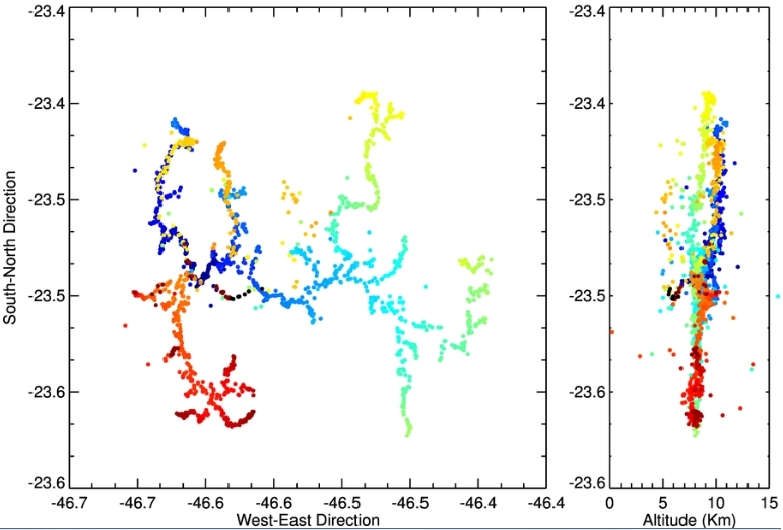
The researchers used a network of sensors that detected each lightning stroke in three dimensions. In addition to latitude and longitude, which were always measured in previous studies, they determined the height of each part of each lightning stroke within the cloud. Measurements were made as part of the SOS-CHUVA campaign in the Paraíba Valley region of São Paulo State and were coordinated by INPE.
The Lightning Mapping Array (LMA), as the sensor network is known, is the first of its kind installed in Brazil and consists of 12 ground sensors covering metropolitan São Paulo. Through the electromagnetic radiation emitted by lightning strokes, the network determines all three coordinates of each point along their propagation lines.
“Our measurements were obtained by means of an international collaboration involving INPE, USP, NASA, and NOAA, which runs the US national weather service and measured the electrical discharges,” said Luiz Augusto Toledo Machado, who supervised Vieira Mattos’s PhD research and is also a co-author of the article in the Journal of Geophysical Research.
NASA, the National Aeronautics & Space Administration, is an independent agency of the executive branch of the US federal government. NOAA, the National Oceanic & Atmospheric Administration, is an operating unit of the Department of Commerce.
In addition to the LMA, the researchers used the polarimetric radar to distinguish between liquid water and ice particles in clouds to detect whether their shapes were spherical, conical or oblong, and to determine whether their main axes were horizontally or vertically aligned. The device also showed whether ice was mixed with liquid water in specific cloud regions.
“The LMA sensors enabled us to determine which clouds had lightning activity and which didn’t, and to pinpoint the position of lightning events within clouds. We used the radar to analyze each cloud layer separately, from bottom to top. This enabled us to associate the occurrence of lightning events with the microphysical properties of each layer and based on that to construct the conceptual model for lightning forecasts,” Vieira Mattos said.
“Clouds that are highly likely to produce lightning have a great deal of conically shaped ice particles in the temperature range between zero and minus 15 degrees Celsius. In the same region they also contain many crystals of ice and supercooled liquid water.
“This mixture consisting of conical ice particles and high concentrations of crystals of ice and supercooled liquid water, associated with the existence of intense vertical currents, leads to a higher rate of particle collision. The result is ionization and separation of electrical charges, the necessary condition for electrical discharges to occur.
“Furthermore, near the top in the region we call the glaciated phase, where temperatures fall below minus 40, these huge clouds also have a very intense electrical field, which vertically aligns the axes of the ice crystals. This is another important marker.”
The combination of these two ingredients clearly characterizes lightning-producing clouds. They have a strong mixture of conical ice particles, crystals of ice and supercooled liquid water between zero and minus 15, and vertically aligned ice crystals at minus 40. Thus, it is possible to know whether a cloud is likely to produce electrical discharges by using radar to observe its polarimetric properties, i.e., the shape and orientation of the ice. The model can predict this in quasi-real time – only half an hour in advance.
A second important outcome of the study is the possibility of doing the reverse – starting with an inventory of lightning events to characterize or estimate the microphysical profiles of the clouds. This kind of inventory is now feasible practically in real time thanks to the November 2016 launch of GOES 16, a weather satellite that forms part of the Geostationary Operational Environmental System (GOES) operated by the NOAA.
“GOES 16, which before its launch was called GOES R, is the most advanced geostationary satellite in existence. NOAA has invested about US$11 billion in the GOES program. Its various sensors include one that measures electrical discharges called Geostationary Lightning Mapper, or GLM. It maps all the lightning events in North, Central and South America every 15 minutes,” Toledo Machado said.
“By associating this information with the model developed based on Vieira Mattos’s research, we were able to characterize cloud profiles in terms of their microphysical composition. An analogy would be a CT scan of cloud formations and the composition of their layers every 15 minutes, thanks to the model combined with monitoring by GOES 16. This information is very important for numerical weather prediction, which always builds on an initial state that evolves over time. We’re talking about new forecasting models that are very different from those used until now. They’re models with a resolution on the order of 1 km, so that weather forecasts on the neighborhood scale are possible.”
Rapid and precise forecasting is highly necessary at a time of global climate change, when extreme weather events tend to occur more and more frequently. The number of lightning strokes varies from a few dozen to thousands depending on the storm intensity (updrafts) and the microphysical composition of the clouds (e.g., type, size, ice concentration). Mesoscale cloud systems, which extend horizontally for thousands of square kilometers, produce lightning strokes in the 100 km range along their central propagation lines.
Ninety percent of lighting activity propagates within clouds, and this internal propagation precedes cloud-to-ground discharges. For this reason, quasi-real-time monitoring by GOES 16 is a great help to decision making by civil defense and emergency management agencies.
The Agency FAPESP licenses news via Creative Commons (CC-BY-NC-ND) so that they can be republished free of charge and in a simple way by other digital or printed vehicles. Agência FAPESP must be credited as the source of the content being republished and the name of the reporter (if any) must be attributed. Using the HMTL button below allows compliance with these rules, detailed in Digital Republishing Policy FAPESP.
