
Equipment was built to improve forecasting and the monitoring of possible climate changes
Equipment was built to improve forecasting and the monitoring of possible climate changes.
Equipment was built to improve forecasting and the monitoring of possible climate changes.

Equipment was built to improve forecasting and the monitoring of possible climate changes
By Noêmia Lopes
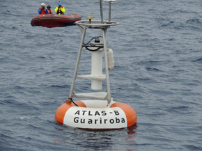
Agência FAPESP – A buoy with sensors for atmospheric and oceanic monitoring that was built entirely in Brazil has been anchored at a depth of 3,700 meters in the southeast of the South Atlantic since April of this year.
The objective is to collect the data needed to improve predictions of temperature increases and the occurrence of extreme events, such as the strong rainfall event that occurred in the mountainous regions of Rio de Janeiro in 2011 and Hurricane Catarina, which struck southern Brazil in 2004.
Such events trigger interactions between atmospheric variables such as precipitation, humidity, wind, and radiation and ocean characteristics such as salinity, temperature, and pressure. These interactions influence climatic conditions in Brazil and throughout South America.
“We need continuous monitoring of these data to accompany our current climatic conditions and to better prepare ourselves for extreme changes and occurrences,” affirmed Regina Rodrigues, a researcher at the Universidade Federal de Santa Catarina (UFSC), during the 1st National Conference on Global Climate Change (Conclima), held in São Paulo.
In the equatorial and tropical portions of the Atlantic Ocean between Brazil and Africa, this type of monitoring has been conducted using a series of North American-made buoys belonging to Projeto Pirata, a joint program between France, Germany, and the United States. The subtropical portion, however, still needs attention—a gap that the buoy in question, the Atlas-B Guariroba, was developed to help fill.
The equipment was built by a group of researchers at the Universidade de São Paulo’s Oceanography Institute (IO-USP), including Rodrigues. The buoy development project was coordinated by Edmo Campos.
“We decided to develop a buoy in Brazil to have more autonomy in relationship to external manufacturers, which helped us to learn the necessary technology and more freedom to choose the ideal position for the buoy,” said Rodrigues.
Scientists conducted an anchoring test in Ubatuba in November 2012 and made the definitive placement 600 kilometers off the coast of Santa Catarina State (28.5° S, 44°W) in April of this year. On both occasions, the researchers travelled to board the Alpha Crucis oceanographic vessel, acquired by FAPESP for IO-USP.
Functioning and prospects
The information relative to atmospheric phenomena are registered by Atlas-B Guariroba using sensors situated in an upper tower of the floating device: pluviometers to gauge rainfall quantities, anemometers to measure the direction and speed of the wind, spectroradiometers to measure solar radiation, thermometers, GPS equipment, and gauges to measure the carbon gas concentration and the relative humidity.
The underwater portion of the buoy has a 4,000-meter cable fixed to the sea floor. Along the first 500 meters of the cable from the surface, there are sensors such as fluorometers (which measure the concentration of fluorescence), spectroradiometers, thermometers, and water salinity gauges.
The data are transmitted via satellite, which allows the creation of time series for each variable.
“A portion of the Guariroba parts came from one of the Projeto Pirate buoys. However, we have already built a second buoy made solely from our components, which will be anchored in April 2014,” explained Rodrigues. At that time, one year after it began operation, Atlas-B will be temporarily retrieved for maintenance. The second buoy will be anchored in place of the first to maintain a continuous data record.
According to the researcher, retrieving the buoy for maintenance will allow scientists to confirm whether the variations identified to date are real or the results of damage to the equipment. “A year is a reasonable time for us to release the data for scientific purposes.” Once verified, the information will be part of the online system of Projeto Pirata, which can be used to retrieve data from different individual buoys.
The main partners of the initiative are two private companies from Rio de Janeiro, Ambidados, and Holos, along with the Universidade Federal do Rio Grande (FURG), the Brazilian Marines Hydrography and Navigation Department, and the National Institute for Space Research. Funding for the development of the buoy was provided by the FAPESP Program on Global Climate Change (PFPMCG), the National Institute of Science and Technology for Climate Change (INCT-MC), and the USP Research Support Center.
“Our intention is to keep Atlas-B Guariroba as a pilot project with the assistance of different programs until the National Institute of Oceanographic and Waterway Research [a body created in May of this year] can take full control of the project,” added Rodrigues.
These data were presented during the 1st National Conference on Global Climate Change. More information on the event is available at www.fapesp.br/conclima.
Republish
The Agency FAPESP licenses news via Creative Commons (CC-BY-NC-ND) so that they can be republished free of charge and in a simple way by other digital or printed vehicles. Agência FAPESP must be credited as the source of the content being republished and the name of the reporter (if any) must be attributed. Using the HMTL button below allows compliance with these rules, detailed in Digital Republishing Policy FAPESP.


