


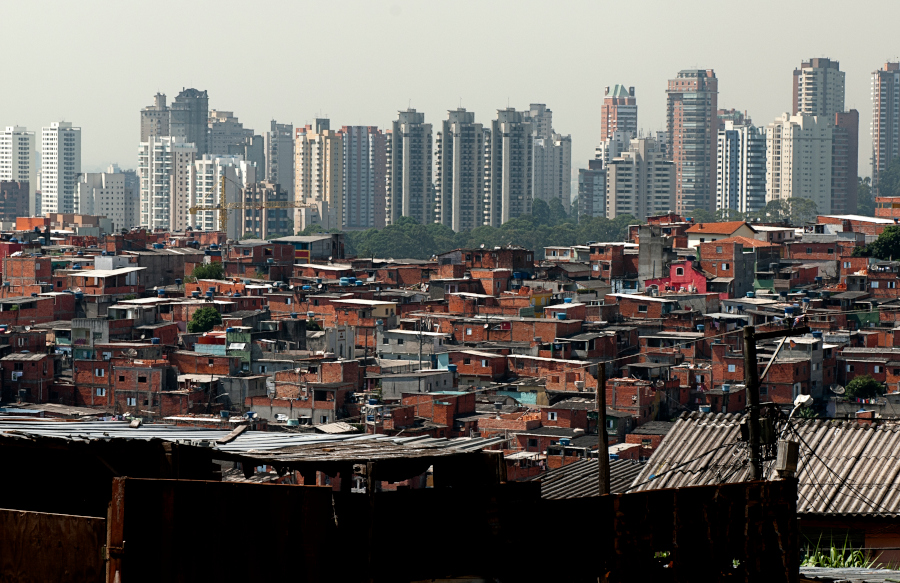
Paraisópolis favela is an example of the internal heterogeneity of precarious settlements, according to a CEM study (photo: Léo Ramos Chaves/Pesquisa FAPESP)
Research by a FAPESP-supported center indicates that the favela formation process is ongoing but slowing down.
Research by a FAPESP-supported center indicates that the favela formation process is ongoing but slowing down.
Paraisópolis favela is an example of the internal heterogeneity of precarious settlements, according to a CEM study (photo: Léo Ramos Chaves/Pesquisa FAPESP)
Agência FAPESP* – The population in precarious areas of the São Paulo Metropolitan Area (SPMA) in Brazil is estimated at 3.28 million people in 1.12 million households, according to research by Eduardo Marques, a researcher and director of the Center for Metropolitan Studies (CEM), and professor at the University of São Paulo (USP).
The CEM is a FAPESP Research, Innovation, and Dissemination Center (RIDC) based at USP and the Brazilian Center for Analysis and Planning (CEBRAP) .
These figures surpass the Brazilian Institute of Geography and Statistics’ (IBGE) estimates of 2.9 million inhabitants in nearly one million households in favelas. However, comparisons with other censuses indicate a slow convergence between the estimates. Areas characterized as favelas and irregular, clandestine subdivisions are considered precarious settlements and are estimated using statistical methods.
The study also highlights the persistence of significant inequalities. For instance, average incomes reach nearly BRL 5,000 in non-precarious areas, compared to approximately BRL 1,700 in precarious areas. The municipalities with the highest absolute numbers of people residing in these areas are São Paulo, Guarulhos, São Bernardo, Mauá, Osasco, Itaquaquecetuba, Santo André, and Diadema. Marques presents and discusses these and other results of the research in the 22nd Technical Note on Public Policies, Cities, and Inequalities of the CEM, “Estimating and Characterizing Urban and Housing Precariousness in São Paulo in 2022”.
The study indicates that the formation of favelas is ongoing because these areas have a higher population growth rate than other regions of the SPMA. However, the phenomenon has not exploded; the population in precarious regions increased by only 0.86% per year between the 2010 and 2022 IBGE demographic censuses, compared to 0.74% per year for the population as a whole. Marques also points out that the growth rate of households is higher than the population growth rate in precarious areas. This indicates a reduction in household density, with fewer inhabitants per residence. This pattern follows that of the metropolitan area as a whole.
The CEM developed the methodology used in the study based on previous studies from 2008 and 2013. The methodology uses statistical analysis and geoprocessing of census tract data and urban research from the 2022 IBGE Demographic Census, as well as visual interpretation of satellite images. While the research provides a certain level of detail, it cannot estimate numbers and indicators for specific settlements; it can only do so for aggregate scales.
There are still significant inequalities and poorer living conditions in precarious regions, including those related to social and urban housing characteristics, compared to the rest of the metropolitan area.
Degrees of precariousness
“In general, it can be said that precarious areas are home to a much poorer, younger, more black and brown population, with less older adults and more very young, female, and black and brown heads of households, as well as having a higher adult illiteracy rate,” points out the CEM director.
Despite this general overview, precarious regions include significant diversity within their territories. There is significant variability in population density and access to infrastructure between and within settlements. Marques’s research quantifies and maps this diversity through cluster analysis.
According to the researcher, the main dimensions of heterogeneity in precarious areas are associated primarily with the physical structure of the settlements and access to services and infrastructure rather than with the social characteristics of the residents, such as income, age, and education.
To better understand and map this heterogeneity, Marques proposed categorizing areas by levels of precariousness. He defined four groups according to housing density, the availability of water supply, sewage collection and treatment, garbage collection, road infrastructure (paving, storm drains, lighting, and sidewalks), and the presence of trees. The indicators generated show that the most intense precariousness and excessive housing density are concentrated in about one-fifth of the settlements.
Group 1 consists of areas on the frontiers of expansion with lower densities and precarious services. Group 2 has a medium-low population density, while Group 3 has a medium density and Group 4 corresponds to superdense, consolidated areas. Access to services gradually increases from the second to the fourth group in terms of water, sewage, paving, and car access. However, access or availability gradually worsens in the case of lighting, storm drains, sidewalks, and trees.
“In the metropolis as a whole, the incidence of precarious sectors is relatively even – 19% in the first type, 32% in the second, 35% in the third, and 14% in the last,” he explains. The larger municipalities – São Paulo, Santo André, São Bernardo, and Mauá – follow approximately the same distributions, with most of the precarious sectors in Groups 2 and 3. Guarulhos, on the other hand, has more settlements of the first type, urban expansion, Osasco of the third, and Diadema of the last type.
The mapping of the groups reveals their spatial distribution in the Metropolitan Area. The Southwest and Southeast regions, which encompass parts of the South Zone of São Paulo, Osasco, Taboão da Serra, and the ABC region, include the two largest favelas in the state capital: Paraisópolis and Heliópolis. These are examples of how heterogeneous and internally precarious settlements can be. Both have a high concentration of Group 3, which is of medium density, and Group 4, which is superdense. In São Paulo, there is also a higher incidence of intermediate types south of Jardim Ângela district and in the southernmost part of Cidade Dutra district, between the Guarapiranga and Billings dams. The East and North regions of the Metropolitan Area also show heterogeneity, but with a greater relative presence of lower-density groups.
Therefore, the heterogeneity combines the peripheral character with the municipality and region of the macrometropolis in which it is located. “It’s likely that this heterogeneity stems from the processes of producing spaces in the various regions of the metropolis, including localized processes of favela formation and municipal favela urbanization programs,” Marques points out. “Only more localized studies will be able to confirm this hypothesis,” he concludes.
The research can be read in a technical note published by the CEM.
* With information from the CEM
The Agency FAPESP licenses news via Creative Commons (CC-BY-NC-ND) so that they can be republished free of charge and in a simple way by other digital or printed vehicles. Agência FAPESP must be credited as the source of the content being republished and the name of the reporter (if any) must be attributed. Using the HMTL button below allows compliance with these rules, detailed in Digital Republishing Policy FAPESP.
