


According to the researcher, the approach has the potential to monitor and prevent a number of other environmental problems, such as fires, deforestation, land subsidence, and desertification (image: Civil Defense/Wikimedia Commons)
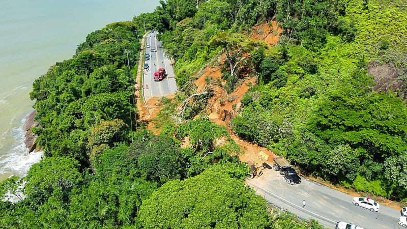
Strategy formulated by Brazilian researchers objectively defines the weight of each contributing factor and was validated based on inventories of landslides that killed 65 people on the northern coast of São Paulo.
Strategy formulated by Brazilian researchers objectively defines the weight of each contributing factor and was validated based on inventories of landslides that killed 65 people on the northern coast of São Paulo.
According to the researcher, the approach has the potential to monitor and prevent a number of other environmental problems, such as fires, deforestation, land subsidence, and desertification (image: Civil Defense/Wikimedia Commons)
By Reinaldo José Lopes | Agência FAPESP – A relatively simple statistical analysis method can more accurately predict the risk of landslides caused by heavy rain, according to a study coordinated by Brazilian researchers affiliated with the Institute of Mathematical and Computer Sciences at the University of São Paulo (ICMC-USP) in São Carlos and the National Institute for Space Research (INPE). The researchers validated their strategy based on a real event. In February 2023, the municipality of São Sebastião, on the northern coast of São Paulo, experienced unprecedented storms – 683 millimeters (mm) of rain fell in less than 15 hours, compared to a monthly average of 300 mm – which killed 65 people and left hundreds homeless.
In an article published in the journal Scientific Reports, the team compared the efficiency of their approach with the traditional method used for these types of analyses. Overall, the evaluated technique performed slightly better, with a more accurate classification of areas that may be affected by disasters.
“Although the quantitative gains are modest, the method has significant advantages. It reduces ambiguities and is more aligned with the actual behavior of landslides in the territory,” explains Rômulo Marques-Carvalho, a doctoral student at the ICMC-USP and first author of the study.
One of the most commonly used methods in assessments of this type of risk is called AHP (analytical hierarchy process). This approach uses a list of relevant variables for the phenomenon under investigation. In this study, the list includes 16 items, such as elevation, terrain steepness and ruggedness, proximity to rivers and roads, and land cover (vegetation and buildings).
In the “classic” AHP, these factors are compared in pairs to determine the importance of each variable. This process also involves the opinions of experts regarding the relative importance of each factor in triggering the event. In the new study, the team applied Gaussian AHP, which, according to Marques-Carvalho, uses statistical methods that “completely replace the paired comparisons of the traditional AHP.”
“The term refers to the fact that the method adopted in the study uses the Gaussian distribution or Gaussian curve, also called the normal distribution,” explains Cláudia Maria de Almeida, co-author of the study and a researcher at the INPE. “It’s equivalent to the probability distribution curve, defined by two parameters: the mean and the standard deviation, which indicates the dispersion of the data.” This helps define the weights of each factor objectively. The list of factors is the same in both approaches, according to Marques-Carvalho.
To validate the method, the researchers used data from São Sebastião, one of the municipalities most susceptible to landslides in the state of São Paulo according to an analysis by the authors based on the Index of Vulnerability to Natural Disasters Related to Landslides. The team relied on an inventory of aerial images taken after the February 2023 disasters, with a resolution of 10 cm. This inventory was supplemented with photos from the Google Earth and PlanetScope platforms.
The main structures cataloged in the images include 983 crown points of landslides, which are located at the top of a slope where the process begins. Additionally, there are 1,070 “scar polygons,” which delineate the entire area affected by the landslide.
Based on this data, Gaussian AHP classified 26.31% of the analyzed area as having very high susceptibility to landslides, compared to an estimate of 23.52% using traditional AHP. This demonstrates that the predictive power of the new method is superior.
Supported by FAPESP (projects 24/02748-7, 21/11435-4, and 20/09215-3), the work also assigned different weights to the main variables. In traditional AHP, the most important factors are variation in slope inclination and position, while in the Gaussian AHP analysis, the most important factors are geomorphology (surface relief forms) and distance from the affected area to rivers and roads.
“The proximity of roads is important because constructing them in rugged terrain requires earthworks, such as cuts and embankments, which generally lead to slope instability,” explains Almeida.
According to André Ferreira de Carvalho, the current advisor of Marques-Carvalho, the approach has the potential to monitor and prevent environmental problems such as fires, deforestation, soil subsidence, and desertification. “Due to climate change, the frequency and intensity of these disasters will increase in the coming years,” he notes.
“The method is simple to apply,” says the first author of the study. “A city government would only need basic geospatial data and a standard computer with QGIS [free georeferenced data analysis software].”
The article “Comparative analysis of traditional and Gaussian Analytical Hierarchy Process (AHP) methods for landslide susceptibility assessment” is available at www.nature.com/articles/s41598-025-22136-6.
The Agency FAPESP licenses news via Creative Commons (CC-BY-NC-ND) so that they can be republished free of charge and in a simple way by other digital or printed vehicles. Agência FAPESP must be credited as the source of the content being republished and the name of the reporter (if any) must be attributed. Using the HMTL button below allows compliance with these rules, detailed in Digital Republishing Policy FAPESP.
