


Mission impossible: Although observing the shape and movement of a barchan dune (crescent-shaped) allows us to infer wind direction and average intensity, calculating the resulting force on each grain of sand was considered impossible (image: Wikimedia Commons)
Possible applications of a study conducted at the State University of Campinas range from controlling river silting and beach erosion to studying the evolution of the surface of Mars.
Possible applications of a study conducted at the State University of Campinas range from controlling river silting and beach erosion to studying the evolution of the surface of Mars.
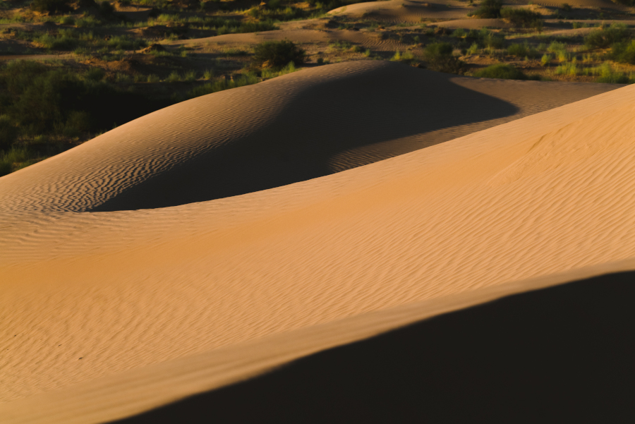
Mission impossible: Although observing the shape and movement of a barchan dune (crescent-shaped) allows us to infer wind direction and average intensity, calculating the resulting force on each grain of sand was considered impossible (image: Wikimedia Commons)
By José Tadeu Arantes | Agência FAPESP – Brazilian researchers have developed a technique that estimates the force exerted on each grain of sand in a dune from images. This method, which is based on numerical simulations and artificial intelligence (AI), transforms the study of granular system dynamics and paves the way for investigating previously unmeasurable physical processes. Applications range from civil engineering to space exploration.
The results were published in the journal Geophysical Research Letters.
The research focused on “barchan dunes,” which are crescent-shaped structures whose tips are oriented in the direction of wind or water flow. “These dunes appear in very different environments: inside pipes, at the bottom of rivers and seas, in terrestrial deserts, and even on the surface of other planets, such as Mars. This crescent moon shape is an attractor. So, all you need is a reasonable amount of grains on non-erodible soil and a fluid flowing in one direction for a barchan to form,” explains Erick Franklin, professor at the Faculty of Mechanical Engineering at the State University of Campinas (FEM-UNICAMP) and coordinator of the study.
The scales involved vary enormously. In a laboratory aquatic environment, they can be as small as 10 centimeters and complete a displacement in less than a minute. In Earth’s deserts, they measure around 100 meters and move over the course of a year. On Mars, they can reach one kilometer and take about a thousand years to move. “Despite this difference in scale, the underlying dynamics are very similar,” Franklin points out. This is what makes it possible to predict the evolution of the surface of Mars from a small laboratory dune.
Simply observing the shape and movement of a dune allows us to infer information about the direction and average intensity of the winds. However, knowing the resulting force on each grain of sand has always been considered an impossible task. It is easy to understand why. “A laboratory underwater dune can have 100,000 grains, each 0.2 millimeters in diameter. To measure the force acting on each grain, you’d need to place a tiny accelerometer on each one, which simply doesn’t exist. In terrestrial desert dunes, the number of grains increases to 10¹⁵ [1 quadrillion], and in Martian dunes, to 10¹⁷ [100 quadrillion],” explains the researcher.
Even with high-speed cameras and advanced motion measurement techniques, the force acting on each grain has always been beyond experimental reach. The solution was to combine laboratory experiments with underwater dunes, which form and move in a matter of minutes, with numerical simulations, which allow the dynamics (forces and movements) of each grain to be calculated at every instant.
These simulations have high spatial and temporal resolutions and accurately reproduce the observed dunes. They also provide force maps that cannot be obtained directly on a large scale.
The study paired actual images of the dune surfaces with the force maps produced by the simulations, providing data on each grain in the form of an image and a force measurement. “Based on this, we trained a convolutional neural network to estimate the resulting forces acting on the actual dune grains,” reports Renato Miotto, a postdoctoral researcher at FEM-UNICAMP and visiting researcher at Syracuse University in the United States.
A convolutional neural network (CNN) is an artificial intelligence model designed to process spatially structured data, such as images. CNNs use convolution layers, which apply filters to small regions of the input to detect local patterns (e.g., edges, textures, and shapes) and generate feature maps. With multiple layers, a CNN can combine simple patterns into complex structures, allowing it to recognize objects, classify images, or extract information automatically and efficiently.
CNNs are widely used in computer vision, facial recognition, medical analysis, and other detection and classification tasks. “In the study, the network was able to infer the distribution of forces from simple images of dunes and even generalize its predictions to shapes it had never seen before,” Miotto points out.
William Wolf, a professor at FEM-UNICAMP and co-author of the study, emphasizes that special care was required in preparing the data for the process. “We used high-fidelity, three-dimensional simulations, which allow us to obtain high resolution of spatial and temporal scales, giving us a level of detail very close to reality. In this way, details of the dynamics and morphology of the dunes were learned by the CNN, and these are essential parameters for the network to be able to generalize to experimental images.”
Applications
Miotto adds that the methodology is not limited to sand: “Any granular system that can be seen in an image – whether ice, salt, or synthetic particles – can be analyzed as long as there’s a simulation capable of accurately reproducing the behavior of the material.”
According to the researchers, the technique can be adapted to study other systems formed by moving particles and address specific issues such as river silting, beach erosion, sand movement in ports, and industrial runoff. “These processes have enormous economic costs and affect entire communities. Tools like this can help predict and mitigate damage. In the case of Mars, it’s possible to infer, from widely available images, the intensity of winds in the past and the evolution of dunes in the future,” emphasizes Franklin.
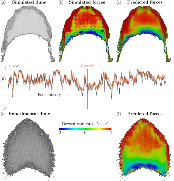
((a) Top view of an underwater barchan dune, obtained from a numerical simulation showing its topology. (b) Instantaneous forces on the dune, calculated by numerical simulation. (c) Prediction of forces obtained by convolutional neural network (CNN). (d) Time history of the indicated force. (e) Top view of an underwater dune obtained from an experiment. (f) Instantaneous forces on the real dune estimated by CNN (image: Erick Franklin et al./Geophysical Research Letters)
Wolf highlights the collaborative nature of the study: “We’ve been working together for years, combining our expertise in flow physics, fluid mechanics, and computational analysis. It’s an example of how continuous support for basic research can generate advances with impacts in multiple areas.”
The study received support from FAPESP through six projects (13/08293-7, 18/14981-7, 19/17874-0, 21/06448-0, 22/01758-3 and 22/09196-4).
The article “Resultant force on grains of a real sand dune: How to measure it?” can be accessed in full at agupubs.onlinelibrary.wiley.com/doi/10.1029/2025GL116942.
The Agency FAPESP licenses news via Creative Commons (CC-BY-NC-ND) so that they can be republished free of charge and in a simple way by other digital or printed vehicles. Agência FAPESP must be credited as the source of the content being republished and the name of the reporter (if any) must be attributed. Using the HMTL button below allows compliance with these rules, detailed in Digital Republishing Policy FAPESP.
