


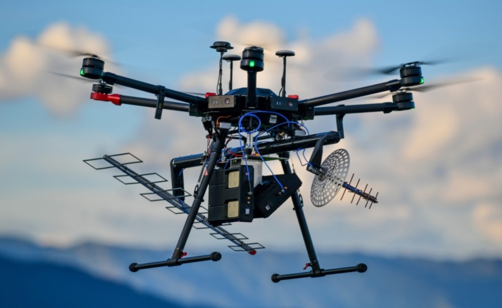
The system, developed by a startup supported by FAPESP, in partnership with researchers at the University of Campinas, helps plantation managers choose the optimal time to harvest the crop (image: Radaz)
The system, developed by a startup supported by FAPESP, in partnership with researchers at the University of Campinas, helps plantation managers choose the optimal time to harvest the crop.
The system, developed by a startup supported by FAPESP, in partnership with researchers at the University of Campinas, helps plantation managers choose the optimal time to harvest the crop.
The system, developed by a startup supported by FAPESP, in partnership with researchers at the University of Campinas, helps plantation managers choose the optimal time to harvest the crop (image: Radaz)
By Elton Alisson | Agência FAPESP – Drones carrying a miniaturized radar system are being used in the interior of the state of São Paulo (Brazil) to monitor sugarcane growth in order to estimate the optimal time for harvesting the crop.
The technology was developed by the startup Radaz with the support of FAPESP’s Innovative Research in Small Business Program (PIPE), in collaboration with researchers at the University of Campinas (UNICAMP), and is described in an article in the journal Remote Sensing.
The 2020-21 Brazilian Bioenergy Science and Technology Conference (BBEST), held online on May 24-26, included a presentation on the drone-borne radar system.
The conference was part of the activities of the FAPESP Bioenergy Research Program (BIOEN), and took place in parallel with the second edition of the Biofuture Summit organized by Biofuture Platform, a 20-country alliance to accelerate low-carbon transportation solutions and the bioeconomy.
“The technology can be used to monitor the growth of any crop. We chose sugarcane because of its significance to the agricultural sector in São Paulo state,” said Hugo Enrique Hernández Figueroa, principal investigator for the project. Figueroa is a professor at UNICAMP’s School of Electrical and Computer Engineering (FEEC).
The drone-borne radar operates simultaneously in three microwave bands (P, L, and C), each with its own frequency and wavelength. The longer the wavelength, the further the signal penetrates into a forest or the ground.
P-band frequency, for example, is low at 400 megahertz (MHz), but the wavelength is 75 cm and it can scan the tops of sugarcane plants or penetrate 50 cm underground in an area with little or no plant cover. L-band is 1.2 gigahertz (GHz) and 25 cm, while C-band is 5.5 GHz and 5.5 cm.
Signals sent down on all three bands are reflected back to the drone-borne radar, supplying data that can be used to create a digital model of the area with crucial information for farmers. “In the case of sugarcane plantations, for example, the data can be used to estimate plant height and volume, as well as moisture. We can also detect problems such as erosion and sinkage,” Figueroa said.
Field testing
The remote sensing radar system has a motherboard that weighs 600 grams. The drone can fly in complex patterns, including circles with variable and helical radii. “This capability enhances spatial resolution up to 27 times compared with monitoring of an area with an airplane making linear passes,” Figueroa said.
As part of a project supported by FAPESP’s Research Partnership for Technological Innovation Program (PITE) and a cooperation agreement with IBM Brazil, the researchers refined the algorithms that interpret the images acquired by the system so as to produce information according to the needs of users and the type of plantation analyzed.
To validate the algorithms, they conducted field tests over an area of experimental cropland belonging to UNICAMP’s School of Agricultural Engineering, planting sugarcane and tracking its growth by means of conventional biometrics and using the drone-borne radar system. The data obtained by the system was similar to the data acquired by conventional technology.
To validate the system’s capacity to estimate the amount of above-ground biomass produced by a field of sugarcane three months after planting, the researchers conducted an experiment on a farm owned by Usina São Martinho, a leading sugar and ethanol producer.
“The results of the study, which was accepted for presentation to an international conference, also showed that predictions made by the system closely matched those made by the farm’s technicians,” Figueroa said.
The article “Crop growth monitoring with drone-borne DInSAR” is at: www.mdpi.com/2072-4292/12/4/615/htm.
The Agency FAPESP licenses news via Creative Commons (CC-BY-NC-ND) so that they can be republished free of charge and in a simple way by other digital or printed vehicles. Agência FAPESP must be credited as the source of the content being republished and the name of the reporter (if any) must be attributed. Using the HMTL button below allows compliance with these rules, detailed in Digital Republishing Policy FAPESP.
