


Particles originated in forest fires in the Center-West and North of Brazil interacted with clouds borne by the cold front coming from the south, causing sky and rain to turn to a dark-grey hue (image: CPTEC)
Particles originated in forest fires in the Center-West and North of Brazil interacted with clouds borne by the cold front coming from the south, causing sky and rain to turn to a dark-grey hue.
Particles originated in forest fires in the Center-West and North of Brazil interacted with clouds borne by the cold front coming from the south, causing sky and rain to turn to a dark-grey hue.
Particles originated in forest fires in the Center-West and North of Brazil interacted with clouds borne by the cold front coming from the south, causing sky and rain to turn to a dark-grey hue (image: CPTEC)
By Karina Toledo | Agência FAPESP – Two systems that monitor atmospheric pollutants, developed over the last two decades with FAPESP’s support, are helping scientists understand the rare phenomena seen in São Paulo City on Monday August 19, when darkness fell suddenly in mid-afternoon and dark-gray rain fell shortly afterward in parts of the metropolitan area.
On Sunday (Aug. 18), a thick plume of particulate matter was detected at over 3,000 m by scientists at the Nuclear and Energy Research Institute (IPEN) using the LIDAR system operated by its Center for Lasers and Applications (CLA). Later, with the aim of satellite imaging provided by NASA and a model that predicts the path of air masses, they concluded that the particles originated in forest fires in progress in the Center-West and North of Brazil, especially Mato Grosso do Sul and Rondônia states, as well as parts of Bolivia.
LIDAR (Light Detection And Ranging) is a surveying method that illuminates a target with laser light and measures the distance traveled by the reflected light. Differences in laser return times and wavelengths are then processed to make digital 3D representations of the target. The LIDAR system at IPEN’s CLA is used for active remote sensing of the atmosphere to detect pollutants and has been developed since 1998 by Eduardo Landulfo as part of several projects funded by FAPESP.
“The system illuminates the sky, and the particles present in the atmosphere reflect the light, which we capture with a telescope. When we analyze the signal, we’re able to identify the type of particle and how far it is from the surface,” Landulfo explained.
The pollution plume began hovering over metropolitan São Paulo between 4 p.m. and 5 p.m. on Sunday, he added, and came from fires that had probably occurred four to seven days previously.
According to Saulo Ribeiro de Freitas, a researcher at Brazil’s National Space Research Institute (INPE), polluted air masses from fires in the Center-West and North of Brazil are typically driven westward at 5,000 m by winds blowing from the Atlantic to the Pacific, eventually hitting the Andes. The smoke then builds up over eastern Amazonas and Acre in the North of Brazil, as well as Venezuela, Colombia and Paraguay, until it is blown southward along the Andes by the anti-cyclone system, with winds circulating anti-clockwise at 3,000 m.
“What happened last week was that this mass of polluted air from the north collided with a cold front coming from the south,” Freitas said. “The winds converged and made the river of smoke bend around toward the Southeast of Brazil. There it became a great pall of smog, with the soot from all those forest fires blending with other pollutants present in the urban atmosphere, such as carbon monoxide, carbon dioxide, ozone, nitrous oxide and methane, and interacting with clouds borne by the cold front.”
Atmospheric transportation of biomass burning emissions across South America has been monitored by INPE’s Center for Weather Forecasting and Climate Studies (CPTEC) since 2003 using a system known as CATT-BRAMS (Coupled Aerosol and Tracer Transport model to the Brazilian developments on the Regional Atmospheric Modelling System), developed by Freitas in collaboration with INPE colleagues Karla Longo and Luiz Flávio Rodrigues, and with FAPESP’s support.
“This is a groundbreaking product that forecasts air quality for up to three days and has been used by several world centers, including the US National Oceanic and Atmospheric Administration (NOAA),” Freitas said. Air quality forecasts by CPTEC can be checked every day at http://meioambiente.cptec.inpe.br.
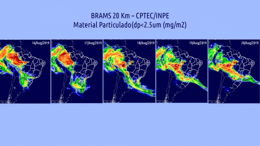
From the images generated by the BRAMS model (photo) it can be seen that on August 16 the “river of smoke” traveled southward as far as Porto Alegre (Rio Grande do Sul) and part of Argentina. It was gradually deflected to the Southeast and by August 20 covered much of São Paulo State.
According to Paulo Artaxo, Full Professor at the University of São Paulo’s Physics Institute (IF-USP), the smoke plume from the burnings interacted with water vapor in the atmosphere during its journey to the Southeast, and altered the properties of the clouds.
“The particles function as water condensation nuclei, forming smaller droplets but in larger quantities, so that more solar radiation is reflected back into space. As a result, it gets very dark on the ground, as we saw that Sunday,” he said.
According to Freitas, the black rain also resulted from this soot-cloud interaction. “The smoke penetrated the droplets of rain, which dumped all the soot on São Paulo City,” he said.
The phenomenon is predictable in terms of atmospheric chemistry, in Artaxo’s view, and should not cause alarm. “It was ugly stuff, this sooty rain, but it didn’t harm people. It simply fell from clouds that were strongly influenced by burnings,” he said.
Analysis of a sample of turbid water collected in an eastern suburb of São Paulo by biologist Marta Marcondes, a professor at the Municipal University of São Caetano do Sul (USCS), showed ten times more sulfides than the average for rainwater. “These substances normally derive from burning of biomass and fossil fuels,” she said. “We were also struck by the large amount of particulate matter collected by the filter. Turbidity was seven times higher than normal.”
Researchers at the University of São Paulo’s Chemistry Institute (IQ-USP) also analyzed the rainwater and detected the presence of rethen, a hydrocarbon produced by biomass burning and considered a wildfire marker. The principal investigator for the study was Pérola de Castro Vasconcellos.
The good news, according to the experts, is that the pollution plume, standing as high in the air as over 3 km, did not adversely affect air quality in São Paulo (altitude of 800 m, approximately). Gauges operated by CETESB, the state’s environmental agency, actually showed satisfactory air quality last week.
“Cities close to the areas in which the fires occurred, such as Cuiabá, Manaus and Porto Velho, suffer most from air quality deterioration,” Freitas said.
Both Freitas (INPE) and Landulfo (IPEN) says transportation of pollutants from burnings in Brazil’s Center-West and North all the way to its Southeast region is fairly common during the dry season between July and September.
“But for it to cause all the effects we’ve seen in the past few days the amount of smoke must have been huge. We don’t yet know if the fires were started deliberately or by accident, which is also common during the dry season,” Landulfo said.
In a press release issued on August 20, however, scientists at the Amazon Environmental Research Institute (IPAM) stated that “Amazonia is burning more in 2019, and the dry season alone cannot explain the increase”.
According to IPAM, the number of fires is at a four-year high in most states and the total recorded until August 14 was 32,728, 60% more than the average for the previous three years. At the same time, the dry season has been less severe this year, indicating that “forest clearing may be one of the reasons for the increase in the number of fires. [...] The top ten Amazon municipalities by number of fires are also the top ten in terms of deforestation”. The scientists based their findings on data from IMAZON’s Deforestation Alert System (SAD), heat imaging from NASA’s Aqua satellite, and rainfall estimates from CHIRPS (Climate Hazards Group Infrared Precipitation with Station Data).
Data from INPE’s DETER system, which issues daily illegal logging alerts as an aid to the environmental law enforcement personnel form IBAMA (Brazilian Institute of the Environment and Renewable Natural Resources), shows a 50% increase in deforestation in the Amazon in 2019. July was the worst month in the time series, with alerts for 2,254 km², up 278% compared with July 2018. Between August 2018 and July 2019, alerts from Deter amounted to 6,833 km², compared with 4,572 km² a year earlier (August 2017-July 2018). The official deforestation rate will be calculated by INPE at the end of 2019, using confirmed data from its PRODES system.
The Agency FAPESP licenses news via Creative Commons (CC-BY-NC-ND) so that they can be republished free of charge and in a simple way by other digital or printed vehicles. Agência FAPESP must be credited as the source of the content being republished and the name of the reporter (if any) must be attributed. Using the HMTL button below allows compliance with these rules, detailed in Digital Republishing Policy FAPESP.
